
Le Bailleul
| Le Bailleul | ||
|---|---|---|
.svg)
|
|
|
| region | Pays de la Loire | |
| Department | Sarthe | |
| Arrondissement | La Flèche | |
| Canton | Sablé-sur-Sarthe | |
| Community association | Sablé-sur-Sarthe | |
| Coordinates | 47 ° 46 ′ N , 0 ° 10 ′ W | |
| height | 34-69 m | |
| surface | 27.46 km 2 | |
| Residents | 1,234 (January 1, 2017) | |
| Population density | 45 inhabitants / km 2 | |
| Post Code | 72200 | |
| INSEE code | 72022 | |
| Website | www.lebailleul.mairie72.fr | |
.jpg) City Hall ( Mairie ) of Le Bailleul |
||

Le Bailleul is a French commune with 1,234 inhabitants (as of January 1 2017) in the department of Sarthe in the region Pays de la Loire . It belongs to the arrondissement of La Flèche and the canton of Sablé-sur-Sarthe (until 2015: canton of Malicorne-sur-Sarthe ). The inhabitants are called Bailleulois .
geography
Le Bailleul is about 37 kilometers southwest of Le Mans . Le Bailleul is surrounded by the neighboring municipalities of Parcé-sur-Sarthe in the north, Arthezé in the northeast, Villaines-sous-Malicorne in the east, Crosmières in the south and southeast, La Chapelle-d'Aligné in the south and southwest and Louailles in the west.
The A11 car route runs through the municipality . The Argance river runs along the southern municipal boundary .
Population development
| 1962 | 1968 | 1975 | 1982 | 1990 | 1999 | 2006 | 2017 |
|---|---|---|---|---|---|---|---|
| 887 | 810 | 780 | 787 | 787 | 850 | 1120 | 1234 |
| Sources: Cassini and INSEE | |||||||
Buildings and sights
- Saint-Pierre church from the 19th century, historic monument since 2007
- Chapel of Sainte-Anne
- La Croix Verte house from the 15th century, former priory of the Order of Malta
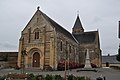
Saint-Pierre church

House La Croix Verte
.jpg)
.JPG)
Personalities
- René Choppin (1537–1606), lawyer