
La Bruère-sur-Loir
| La Bruère-sur-Loir | ||
|---|---|---|
|
||
| region | Pays de la Loire | |
| Department | Sarthe | |
| Arrondissement | La Flèche | |
| Canton | Le Lude | |
| Community association | South Sarthe | |
| Coordinates | 47 ° 39 ′ N , 0 ° 21 ′ E | |
| height | 40-88 m | |
| surface | 11.47 km 2 | |
| Residents | 244 (January 1, 2017) | |
| Population density | 21 inhabitants / km 2 | |
| Post Code | 72420 | |
| INSEE code | 72049 | |

La Bruère-sur-Loir is a French municipality with 244 inhabitants (as of January 1 2017) in the department of Sarthe in the region Pays de la Loire . It belongs to the arrondissement of La Flèche and the canton of Le Lude . The inhabitants are called Bruérois .
geography
La Bruère-sur-Loir is about 38 kilometers south-southeast of Le Mans . The Loir River limits the municipality to the north. La Bruère-sur-Loir is surrounded by the neighboring municipalities of Vaas in the north and west, Montval-sur-Loir in the northeast, Nogent-sur-Loir in the east, Chenu in the south and Saint-Germain-d'Arcé in the west and southwest.
Population development
| year | 1962 | 1968 | 1975 | 1982 | 1990 | 1999 | 2006 | 2013 |
| Residents | 267 | 263 | 235 | 225 | 218 | 256 | 257 | 271 |
| Source: Cassini and INSEE | ||||||||
Attractions
- Saint-Martin church from the 11th century, alterations from the 16th century, monument historique since 1912
- La Maison Rouge Castle, destroyed in 1862, then rebuilt
- La Gagnerie Castle
- Le Grand Perray Castle, built at the end of the 18th century

Saint Martin Church
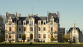
La Maison Rouge Castle


literature
- Le Patrimoine des Communes de la Sarthe. Flohic Editions, Volume 1, Paris 2000, ISBN 2-84234-106-6 , pp. 723-725.
Web links
Commons : La Bruère-sur-Loir - Collection of images, videos and audio files