
Beaume (Ardèche)
|
Beaume Baume |
||
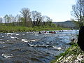
 The Beaume at Labeaume |
||
| Data | ||
| Water code | FR : V5030500 | |
| location | France , Auvergne-Rhône-Alpes region | |
| River system | Rhône | |
| Drain over | Ardèche → Rhône → Mediterranean | |
| source | in the municipality of Loubaresse, 44 ° 36 ′ 14 ″ N , 4 ° 3 ′ 11 ″ E |
|
| Source height | approx. 1280 m | |
| muzzle | in the municipality of Labeaume in the Ardeche Coordinates: 44 ° 26 ′ 10 ″ N , 4 ° 19 ′ 57 ″ E, 44 ° 26 ′ 10 ″ N , 4 ° 19 ′ 57 ″ E |
|
| Mouth height | approx. 99 m | |
| Height difference | approx. 1181 m | |
| Bottom slope | approx. 27 ‰ | |
| length | 44 km (see notes) | |
| Left tributaries | Salindres | |
| Right tributaries | Drobie | |
The Beaume , often also called Baume , is a river in France that runs in the Ardèche department in the Auvergne-Rhône-Alpes region . Its source stream Ruisseau de Fromental rises in the Regional Nature Park Monts d'Ardèche , west of the Col de Meyrand , in the municipality of Loubaresse . The Beaume generally drains in a south-easterly direction and flows into the Ardèche as a right tributary after 44 kilometers south of Ruoms , in the municipality of Labeaume .
Places on the river
Attractions
The Beaume is known as the scenic wild river of the Cevennes , which partly flows through deep, wild and romantic gorges. Particularly the lower course without a parallel street is a tourist highlight in the Ardèche region. Kayak trips in the middle and lower reaches are very popular, as are hikes on old paths between Labeaume and Rosières. Many campsites offer holidays close to nature.
Flora and fauna
The banks are characterized by alders, willows and evergreen shrubs. There are hardly any aquatic plants in the clear, mostly fast-flowing water. The beaver has recaptured an ideal habitat in the karst caves on the bank. The gray heron is a striking waterfowl . The griffon vulture roams the valley in search of food.
Web links
Beaume Valley picture gallery

On old mule tracks near Labeaume
Beginning of the lower reaches at Rosières

Bridge in Labeaume


