
Monts d'Ardèche Regional Natural Park

The Regional Natural Park Monts d'Ardèche ( French Parc naturel régional des Monts d'Ardèche ) is located in the two southern French departments of Ardèche and Haute-Loire in the Auvergne-Rhône-Alpes region .
History and dates
The history of the park goes back to an initiative by chestnut owners in 1992. The nature park, inaugurated in 2001 and expanded in 2014, covers an area of around 2280 km². There are 145 communities ( communes ) with a total of about 75,000 inhabitants; six cities on the edge of the park are associated as access points. They are:
The parking management is located in the lock ROCHEMURE in Jaujac ( 44 ° 38 ' N , 4 ° 16' O ).
The nature park is from the since 2014 UNESCO under the brand name Geopark Ardèche as a UNESCO Global Geopark excellent. This designation stands for the great geological importance of a territory and contributes to the tourist and economic development of the area, taking into account the required sustainability .
Landscapes
The area of the wooded nature park is on the eastern edge of the Massif Central and comprises a diverse, richly structured landscape at an altitude of 170 to 1753 m above sea level. d. Larger rivers and streams and other surface waters are rare because of the predominant limestone subsoil - the Ardèche river and its tributary Fontolière , which is only about 20 km long, divide it roughly in the middle; the Loire rises on Mont Gerbier-de-Jonc .
Mont Gerbier-de-Jonc (1551 m)

River Eyrieux at Saint-Fortunat-sur-Eyrieux

Ridge of the Tanargue massif (1511 m)

Mont Mézenc (1783 m) in winter
Suc de Montivernoux (1441 m)
.JPG)


The main zones of the park are:
- The Boutières
In the north, between Saint-Agrève and Privas, lies the Boutières area . The territory lies in the catchment area of the Eyrieux and its tributaries and is characterized by steep slopes. With the help of man-made terraces , the focus of agricultural production has been focused on the production of sweet chestnuts for generations . The stone walls , with which the terraces have been built and maintained for generations, have a lasting impact on the landscape.
- The Vernoux plateau
In the northeast is the plateau of Vernoux with its eponymous town Vernoux-en-Vivarais, just outside the park, which forms a real enclave in the Boutières landscape. With an average height of 500 meters, the plateau rises above the Eyrieux valley. The area consists of rolling hills covered with forests, pastures for cattle and cultures of sweet chestnuts.
- The sucs
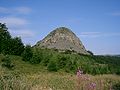
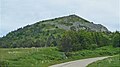
In the northwest is the area of the Sucs . From a geological point of view, this landscape is actually an extension of the Boutières to the west. Particularly characteristic of the Sucs, however, is the clear expression of their volcanic origin through a succession of volcanic cones , which often appear in smaller versions of the Sugar Loaf and are called "Suc" here. The Mont Mézenc (1753 m), which forms the highest point of the nature park, the Suc de Taupernas (1609 m), the Suc de Montivernoux (1441 m) and the Mont Gerbier-de-Jonc (1551 m), at whose foot the Loire has its source are some well-known examples. In this still very pristine landscape, there is a rich flora ( wild tulips , Turkic League ) and fauna ( golden eagles , marmots ).
- The Haute Cevenne
The Haute Cévenne landscape in the center is actually the northeastern extension of the Cevennes massif. This area is also called the "land of young volcanoes" because they erupted late, around 12,000 to 80,000 years ago. Here, too, a multitude of terrain forms of volcanic origin such as volcanic cones, volcanic craters and maars can be recognized. The rivers Bézorgues , Volane and Sandron converge in a fan shape at the thermal resort of Vals-les-Bains and finally flow into the Ardèche , whose source is not far from the Col de la Chavade . The Haute Cévenne also has a strongly incised terrain and, similar to the Boutières, the culture of sweet chestnuts is practiced on many terraces .
- The Cévenne Méridonale
In the south-west lies the Cévenne Méridonale area , which is of a low mountain range . In the north of this landscape lies the imposing Tanargue massif with the summit Sommet de Mejan (1458 m), in the south it is bordered by the Serre de Barre at an altitude of about 900 meters. The west runs along the border with the neighboring Lozère department , where a tangle of steep slopes made the country inaccessible for a long time. Small villages nestle against the mountain slopes, including Saint-Laurent-les-Bains , a small thermal bath. The further one penetrates into the southern area, the more the landscape changes and increasingly takes on a Mediterranean look. In the area of the town of Les Vans, the olive tree finally replaces the sweet chestnut, the garid areas are interspersed with gorse , granite and slate soils give way to the limestone in which the Chassezac river digs deep ravines.
- The Piémont Cévenol
In the southeast of the park is the Piémont Cévenol , which stretches in a narrow strip between Aubenas and Les Vans. The Piémont Cévenol is the part of the park that most intensely diffuses the Mediterranean landscape. As you leave the low mountain range, the chestnut plantations on the terraces are replaced by grapevines , and olives are already grown around the town of Les Vans. The Beaume and Drobie Rivers , the main watercourses in this area, are widely used by whitewater enthusiasts. The animal world also has some special features to offer here: the genette , a wild gorse cat , prefers the proximity of the water and the rocks of the Piémont Cévenol. Especially the hoopoe , the Mediterranean warbler and the cicadas are typical fauna representatives of the Mediterranean region.
See also
Web links
- Monts d'Ardèche Regional Nature Park website (French)
- Monts d'Ardèche Regional Natural Park, photos + information (French)
- Live and create in the Ardèche Mountains (French)
- Chestnut Museum in Saint-Pierreville (French)