Ruoms
| Ruoms | ||
|---|---|---|

|
|
|
| region | Auvergne-Rhône-Alpes | |
| Department | Ardèche | |
| Arrondissement | Largentière | |
| Canton | Vallon-Pont-d'Arc | |
| Community association | Gorges de l'Ardèche | |
| Coordinates | 44 ° 27 ' N , 4 ° 21' E | |
| height | 80-252 m | |
| surface | 12.14 km 2 | |
| Residents | 2,253 (January 1, 2017) | |
| Population density | 186 inhabitants / km 2 | |
| Post Code | 07120 | |
| INSEE code | 07201 | |
| Website | www.ruoms.fr | |
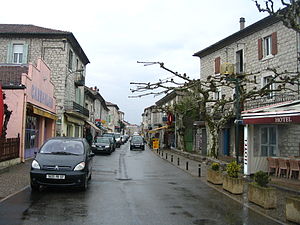
 Downtown Ruoms |
||
Ruoms is a touristic French commune with 2,253 inhabitants (as of January 1, 2017) in the Ardèche department .
geography
The municipality is located directly on the Ardèche river , which is dammed here at a small weir . The Beaume and the Chassezac flow into this river nearby . The area of the place is 1,214 hectares (12.14 km² / 4.69 sq mi), the height varies between 80 m and 252 m above sea level. Climatically the place belongs to the Mediterranean climate.
history
The place was founded in the 3rd century. At the confluence of three rivers (Ardèche, Beaume and Chassezac) lies the medieval village of Ruoms. It was formed in the tenth century near a priory built by the monks of Cluny Abbey . The “Chapel of Our Lady” (La Chapelle Notre Dame) has been preserved from this period. The historic center of the village is surrounded by a city wall with six towers, which is flanked by a few houses and the church from the eleventh and twelfth centuries.
With the construction of the road along the Ardèche Gorges in 1866 and the expansion of the railway network, which was completed in 1876, Ruoms became an important economic center. As a result, textile factories, limestone quarries for the construction of buildings and breweries (including the famous Bière de Ruoms) settled in this area along the course of the river.
Population development
| year | 1962 | 1968 | 1975 | 1982 | 1990 | 1999 | 2006 | 2017 |
| Residents | 1474 | 1620 | 1700 | 1794 | 1858 | 2132 | 2189 | 2253 |
| Sources: Cassini and INSEE | ||||||||
Economy and tourism
Ruoms is centrally located in the Côtes du Vivarais wine region, a wine cooperative and several wineries market the wine directly to end customers. In addition, Ruoms is a local center for canoeing and outdoor tourism in the region with appropriate campsites and leisure activities. The main source of income nowadays is tourism.
A large market takes place on Friday mornings until around 1 p.m., where you can buy groceries in addition to the usual tourist items. An interactive museum, the Vinimage, has been set up near the church, which provides information about viticulture and the types of wine in the region.
Twin cities
- Geislingen in Germany
- Treiso in Italy
Beer from Ruoms
Tourists know Ruoms primarily for its proximity to the approximately 30 km long canyon of the Ardèche, but this place was also once known for its brewery. This was founded in 1874 as the location of the Carcassonne- based Fritz Lauer brewery and produced different types of beer. In the end, it could no longer meet the strict economic requirements of the twentieth century and so it was closed in 1967.
The beers were: BGM (Brasserie Générale du Midi), Bière du Dragon, Bière Lux, Bock Oma, Drakkar Ale, Fritz Lauer, Malz Bräu, Ruoms, Ruoms Export, Scotch 57, Spéciale 57, Spéciale Zénia, Tenauer Pils, Zener, Zener Brau, Zénia, Zénith, Zénith 57.
In addition to the Fritz Lauer brewery, there was also the Hugon-Payan brewery with the Savella beer variety.
Web links
- Website of the municipality (French)
- Brewery history on bierederuoms.blogspot.de (French)
Individual evidence
- ↑ General information about Ruoms on de.db-city.com
- ↑ a b History of the city of Ruoms on ruoms.fr (French)
- ^ City partnership Geislingen / Ruoms on zak.de
- ↑ twinning Treisio / Ruoms on comune.treiso.cn.it (Italian)
- ↑ Breweries and their beers on quid-tegestophile.over-blog.fr (French)


