Labastide-de-Virac
| Labastide-de-Virac | ||
|---|---|---|
|
|
||
| region | Auvergne-Rhône-Alpes | |
| Department | Ardèche | |
| Arrondissement | Largentière | |
| Canton | Vallon-Pont-d'Arc | |
| Community association | Gorges de l'Ardèche | |
| Coordinates | 44 ° 21′N , 4 ° 24′E | |
| height | 40-408 m | |
| surface | 23.32 km 2 | |
| Residents | 301 (January 1, 2017) | |
| Population density | 13 inhabitants / km 2 | |
| Post Code | 07150 | |
| INSEE code | 07113 | |
| Website | www.labastide-de-virac.fr | |
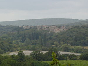
 Panoramic view |
||
Labastide-de-Virac is a municipality with 301 inhabitants (at January 1, 2017) in France , it is in the south of the department of Ardeche in the Region Auvergne Rhône-Alpes .
The village is located in the tourist region west of the Ardèche river , near the border with the Gard department . The municipality of Labastide-de-Virac has an area of 23.32 km², the population density is 11.0 inhabitants per km².
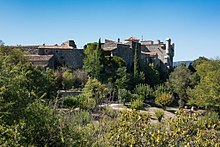
The medieval castle is a listed building and can be visited. It was built at the end of the 14th century and was a shelter for the Count of Rohan, a Huguenot leader, during the Wars of Religion. Today it is a museum where you can admire old furniture, clothing, tools and, as a specialty, the production of natural silk. Live silkworms are in showcases in the various stages up to pupation. The old machines for processing the silk are also on display.
Population development
| year | 1962 | 1968 | 1975 | 1982 | 1990 | 1999 | 2007 | 2017 |
| Residents | 155 | 145 | 155 | 184 | 193 | 218 | 210 | 301 |
| Sources: Cassini and INSEE | ||||||||
Web links
- Information about Labastide-de-Virac (French)


