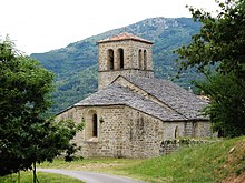
Prunet (Ardèche)
| Prunet | ||
|---|---|---|
|
|
||
| region | Auvergne-Rhône-Alpes | |
| Department | Ardèche | |
| Arrondissement | Largentière | |
| Canton | Canton of Vallon-Pont-d'Arc | |
| Community association | Val de Ligne | |
| Coordinates | 44 ° 36 ′ N , 4 ° 16 ′ E | |
| height | 376-1,193 m | |
| surface | 8.81 km 2 | |
| Residents | 132 (January 1, 2017) | |
| Population density | 15 inhabitants / km 2 | |
| Post Code | 07110 | |
| INSEE code | 07187 | |
Prunet on Occitan "Los Prunetencs" and Latin "Prunus" is a French commune in Ardèche, in the region of Auvergne Rhône-Alpes . It belongs to the canton of Vallon-Pont-d'Arc and the Arrondissement Largentière . The residents call themselves Prunétains or Prunétaines. A local elevation is the Col de la Croix de Millet. Neighboring municipalities are Jaujac in the north-west, Saint-Cirgues-de-Prades in the north, Lentillères in the north-east, Chazeaux in the east, Rocher in the south-east and Joannas in the south-west.
Population development
| year | 1962 | 1968 | 1975 | 1982 | 1990 | 1999 | 2006 | 2011 | 2014 |
|---|---|---|---|---|---|---|---|---|---|
| Residents | 180 | 150 | 118 | 113 | 103 | 104 | 133 | 139 | 132 |
Attractions
- Saint-Grégoire church, Monument historique
- War memorial
Web links
Commons : Prunet - collection of images, videos and audio files


