
Issarlès
| Issarlès | ||
|---|---|---|

|
|
|
| region | Auvergne-Rhône-Alpes | |
| Department | Ardèche | |
| Arrondissement | Largentière | |
| Canton | Haute-Ardèche | |
| Community association | Montagne d'Ardèche | |
| Coordinates | 44 ° 51 ′ N , 4 ° 2 ′ E | |
| height | 850-1,266 m | |
| surface | 18.44 km 2 | |
| Residents | 145 (January 1, 2017) | |
| Population density | 8 inhabitants / km 2 | |
| Post Code | 07470 | |
| INSEE code | 07106 | |
| Website | Issarlès | |
 Issarlès - Church of St-Victor |
||

Issarlès is a place and several hamlets (hamlets) existing and farmsteads community with 145 inhabitants (at January 1, 2017) in the far west of the southern French Ardeche in the historic cultural landscape of the Vivarais near the border with Auvergne .
location
Issarlès is located on a hill on the upper reaches of the Loire in the mountainous landscape of the Monts d'Ardèche , the south-eastern part of the Massif Central , just under 58 km (driving distance) north-west of Aubenas and approx. 35 km south-east of Le Puy-en-Velay at an altitude from approx. 950 m above sea level d. M. The climate is temperate; Rain falls throughout the year.
Population development
| year | 1800 | 1851 | 1901 | 1954 | 1999 | 2014 |
| Residents | 1,231 | 1,464 | 1,740 | 616 | 166 | 153 |
The continuous decline in the number of inhabitants in the 20th century is essentially due to the mechanization of agriculture and the associated loss of jobs. In addition, almost all mountain regions in Europe were depopulated in favor of the valley locations. In 1929, the municipality of Le Lac-d'Issarlès also split off.
economy
Traditionally, the population lived from cattle breeding and a little arable farming on partially terraced fields, which, however, only produced low yields due to the altitude, so that chestnuts often formed the basic supply. Today forestry and tourism play the most important roles in the economic life of the place in the form of the rental of holiday homes ( gîtes ) .
history
Issarlès was - together with Pradelles - a place of jurisdiction ( viguerie ) already in Carolingian times . The place belonged to the diocese of Viviers ; the former priory church of St-Victor is also architecturally indicative of its former dependence on the cathedral chapter of the cathedral of Le Puy-en-Velay . In 1929 the municipality was divided.
Attractions
- In the village there are still some houses made of natural stone with roofs made of stone shingles .
- The church of St Victor , built around the year 1100 in Romanesque style , but fundamentally rebuilt in the middle of the 19th century, shows architectural references to the cathedral of Le Puy, which are evident in the use of gray and red stone material. The two facade towers, the aisles and the polygonal apse are the result of additions and redesigns in the 19th century. The jewel of the church is the central part of its facade with a portal that is staggered several times in depth, the round arches of which rest on columns made of red volcanic rock. The outer arch is formed by a lion frieze, which is reminiscent of similar models in the Auvergne. Above is an early Gothic window with a small quatrefoil in the arched gusset. The interior of the church is spanned by barrel vaults; only in the area of the polygonally broken apse are neo-Gothic rib vaults .

Two-tower facade

Middle part of the facade
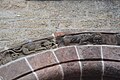
Portal detail

Church interior


Web links
- Issarlès, history - photo + brief information (French)
- Issarlès, church - photos + information (French)