Saint-Gineis-en-Coiron
| Saint-Gineis-en-Coiron | ||
|---|---|---|
|
|
||
| region | Auvergne-Rhône-Alpes | |
| Department | Ardèche | |
| Arrondissement | Largentière | |
| Canton | Berg-Helvie | |
| Community association | Berg et Coiron | |
| Coordinates | 44 ° 38 ′ N , 4 ° 32 ′ E | |
| height | 386-775 m | |
| surface | 13.2 km 2 | |
| Residents | 115 (January 1, 2017) | |
| Population density | 9 inhabitants / km 2 | |
| Post Code | 07580 | |
| INSEE code | 07242 | |
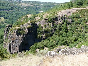
 The medieval cave dwellings Balmes de Montbrun are located on the territory of the municipality |
||
Saint-Gineis-en-Coiron is a French commune with 115 inhabitants (as of January 1, 2017) in the Ardèche department in the Auvergne-Rhône-Alpes region .
geography
The village is located on the southern edge of the Plateau du Coiron between Aubenas in the Ardèche valley and Montélimar on the Rhone .
Attractions
The medieval rock dwellings of the Balmes de Montbrun are located on the territory of the municipality.
Web links
Commons : Saint-Gineis-en-Coiron - Collection of images, videos and audio files
