Saint-Julien-du-Serre
|
Saint-Julien-du-Serre Sant Julian delh Sèrre |
||
|---|---|---|

|
|
|
| region | Auvergne-Rhône-Alpes | |
| Department | Ardèche | |
| Arrondissement | Largentière | |
| Canton | Aubenas-1 | |
| Community association | Basin d'Aubenas | |
| Coordinates | 44 ° 39 ′ N , 4 ° 25 ′ E | |
| height | 224-482 m | |
| surface | 9.78 km 2 | |
| Residents | 879 (January 1, 2017) | |
| Population density | 90 inhabitants / km 2 | |
| Post Code | 07200 | |
| INSEE code | 07254 | |
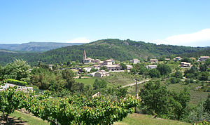
 View of Saint-Julien-du-Serre |
||
Saint-Julien-du-Serre is a French municipality with 879 inhabitants (as of January 1 2017) in the department of Ardèche in the Region Auvergne Rhône-Alpes ; it belongs to the arrondissement Largentière and the canton Aubenas-1 . The inhabitants are called Saint-Julserais .
geography
Saint-Julien-du-Serre is located about four kilometers north-northeast of Aubenas in the northeastern foothills of the Cevennes . The Luol limits the community in the east. It is part of the Monts d'Ardèche Regional Nature Park . Saint-Julien-du-Serre is surrounded by the neighboring communities of Saint-Andéol-de-Vals in the north, Vesseaux in the east, Saint-Privat in the south, Ucel in the southwest and Vals-les-Bains in the west.
Population development
| year | 1962 | 1968 | 1975 | 1982 | 1990 | 1999 | 2006 | 2013 |
| Residents | 268 | 261 | 289 | 442 | 689 | 711 | 815 | 837 |
| Source: Cassini and INSEE | ||||||||
Attractions
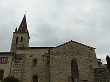
- Saint-Julien church, monument historique since 1906
Web links
Commons : Saint-Julien-du-Serre - Collection of images, videos and audio files

