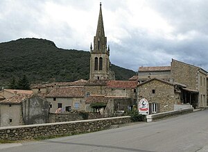
Saint-Sauveur-de-Cruzières
| Saint-Sauveur-de-Cruzières | ||
|---|---|---|
|
|
||
| region | Auvergne-Rhône-Alpes | |
| Department | Ardèche | |
| Arrondissement | Largentière | |
| Canton | Les Cévennes Ardéchoises | |
| Community association | Cèze Cévennes | |
| Coordinates | 44 ° 18 ′ N , 4 ° 15 ′ E | |
| height | 118-448 m | |
| surface | 24.84 km 2 | |
| Residents | 531 (January 1, 2017) | |
| Population density | 21 inhabitants / km 2 | |
| Post Code | 07460 | |
| INSEE code | 07294 | |
| Website | www.saint-sauveur-de-cruzieres.fr | |
 Saint-Sauveur church |
||
Saint-Sauveur-de-Cruzières is a French municipality with 531 inhabitants (at January 1, 2017) in the department Ardèche (07) in the region of Auvergne Rhône-Alpes . It belongs to the Arrondissement Largentière and the canton of Les Cévennes Ardéchoises .
geography
Saint-Sauveur-de-Cruzières is the southernmost commune of the Ardèche department. It is located in the valley of the Claysse River , around 60 km northwest of Orange .
Attractions
- The Saint-Sauveur-de-Cruzières castle: a medieval castle perched on a hill above the village. It was almost completely destroyed in the past, but has recently been rebuilt. It is not open to the public.
- The St. Privas chapel, which offers an impressive view of the village.
population
| year | 1962 | 1968 | 1975 | 1982 | 1990 | 1999 | 2006 | 2017 |
|---|---|---|---|---|---|---|---|---|
| Residents | 398 | 431 | 389 | 409 | 441 | 501 | 519 | 531 |
Web links
Commons : Saint-Sauveur-de-Cruzières - Collection of images, videos and audio files
