Lablachère
| Lablachère | ||
|---|---|---|
|
|
||
| region | Auvergne-Rhône-Alpes | |
| Department | Ardèche | |
| Arrondissement | Largentière | |
| Canton | Les Cévennes Ardéchoises | |
| Community association | Pays Beaume-Drobie | |
| Coordinates | 44 ° 28 ' N , 4 ° 13' E | |
| height | 160–451 m | |
| surface | 26.38 km 2 | |
| Residents | 2,143 (January 1, 2017) | |
| Population density | 81 inhabitants / km 2 | |
| Post Code | 07130 | |
| INSEE code | 07117 | |
| Website | www.lablachere.fr | |
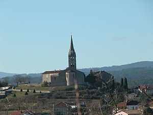
 The church stands at the highest point of the place |
||
Lablachère is a French commune with 2143 inhabitants (as of January 1, 2017), located in the Ardèche department and in the Auvergne-Rhône-Alpes region . It belongs to the Arrondissement Largentière and the canton of Les Cévennes Ardéchoises .
geography
The community lies west of the broad valley of the Beaume . A mountain range connects to the north. South of Lablachère, the Beaume breaks through a karst landscape into the Ardèche valley . The municipality covers 26.38 km².
Population development
| 1962 | 1968 | 1975 | 1982 | 1990 | 1999 | 2016 |
|---|---|---|---|---|---|---|
| 1250 | 1270 | 1277 | 1392 | 1562 | 1520 | 2111 |
Web links
Commons : Lablachère - collection of images, videos and audio files
