Saint-Remèze
| Saint-Remèze | ||
|---|---|---|

|
|
|
| region | Auvergne-Rhône-Alpes | |
| Department | Ardèche | |
| Arrondissement | Largentière | |
| Canton | Vallon-Pont-d'Arc | |
| Community association | Gorges de l'Ardèche | |
| Coordinates | 44 ° 24 ' N , 4 ° 30' E | |
| height | 40-663 m | |
| surface | 42.69 km 2 | |
| Residents | 871 (January 1, 2017) | |
| Population density | 20 inhabitants / km 2 | |
| Post Code | 07700 | |
| INSEE code | 07291 | |
| Website | www.saint-remeze.com | |
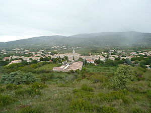
 View from the south |
||
Saint-Remèze is a French commune with 871 inhabitants (as of January 1, 2017) in the Ardèche department . The municipality is located on a high plateau between the towns of Bourg-Saint-Andéol on the banks of the Rhone and Vallon-Pont-d'Arc on the Ardèche .
geography
The municipality of Saint-Remèze on the Les Gras plateau above the Ardeche Gorge between the town of Bourg-Saint-Andéol on the Rhone, 15 kilometers to the west and the municipality of Vallon-Pont-d'Arc on the Ardeche, ten kilometers to the east, is located in Bas Vivarais in the southeast of the department. Saint-Remèze is part of the Côtes du Vivarais wine-growing region .
The Dolmen du Chanet is located near the Ardèche , opposite the Grotte du Parapluie, southwest of Saint-Remèze.
Population development
| year | 1962 | 1968 | 1975 | 1982 | 1990 | 1999 | 2008 | 2017 |
|---|---|---|---|---|---|---|---|---|
| Residents | 429 | 449 | 436 | 474 | 454 | 554 | 845 | 871 |
Abbé Dubois
The Catholic missionary and Indologist Jean Antoine Dubois (1766–1848) comes from Saint-Remèze . The family still runs a winery in the village to this day.
