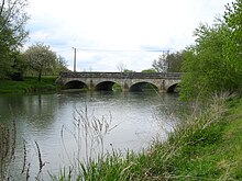
Vingeanne
| Vingeanne | ||
|
Course of the river |
||
| Data | ||
| Water code | FR : U09-0400 | |
| location | France , Grand Est and Bourgogne-Franche-Comté regions | |
| River system | Rhône | |
| Drain over | Saône → Rhône → Mediterranean | |
| source | in the municipality of Aprey 47 ° 45 '32 " N , 5 ° 11' 40" O |
|
| Source height | approx. 410 m | |
| muzzle | below Talmay in the Saône Coordinates: 47 ° 21 '22 " N , 5 ° 29' 18" E 47 ° 21 '22 " N , 5 ° 29' 18" E |
|
| Mouth height | approx. 184 m | |
| Height difference | approx. 226 m | |
| Bottom slope | approx. 2.4 ‰ | |
| length | 93 km | |
The Vingeanne is a river in France that runs in the Grand Est and Bourgogne-Franche-Comté regions. It rises on the plateau of Langres , in the municipality of Aprey , and is dammed up at Villegusien-le-Lac to the Réservoir de la Vingeanne . This serves to supply the Canal entre Champagne et Bourgogne , which the river accompanies in the further course. The Vingeanne generally drains south-east and flows into the Saône as a right tributary about 93 kilometers below Talmay . On its way it crosses the Haute-Marne and Côte-d'Or departments , but also touches the Haute-Saône department over a short distance .
Places on the river
- Aprey
- Bearish
- Villegusien-le-Lac
- Cusey
- Percey-le-Grand
- Saint-Seine-sur-Vingeanne
- Champagne-sur-Vingeanne
- Renève
- Talmay

