Canal between Champagne and Burgundy
| Canal between Champagne and Burgundy | |
|---|---|
|
Canal system in the Champagne-Ardenne region. The Canal entre Champagne et Bourgogne begins at the bottom right |
|
| Water code | FR : F5-0182 , FR : ---- 0182 |
| location | France , Grand Est and Bourgogne-Franche-Comté regions |
| length | 228 km |
| Built | 1862-1907 |
| class | I ( Freycinet class ) |
| Beginning | Crossing from the Canal latéral à la Marne at Vitry-le-François |
| The End | It flows into the canalised Saône at Heuilley-sur-Saône |
| Descent structures | 114 |
| Ports | Vitry-le-François , Saint-Dizier |
| Junctions, crossings | Canal de la Marne au Rhin |
| Historical precursors | Canal de la Haute-Marne |
| Used river | Marne , Vingeanne |
| Outstanding structures | Condes Tunnel, Ballesmes Tunnel |
| Kilometrage | Towards the Saône |
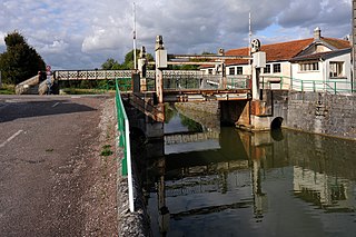
| Lift bridge at Luzy-sur-Marne | |
The Canal entre Champagne et Bourgogne (German: Canal between Champagne and Burgundy ) is a French shipping canal that runs through the Grand Est and Bourgogne-Franche-Comté regions. The canal used to be called Canal de la Marne à la Saône (German: Marne-Saône Canal ).
geography
With a length of 228 kilometers, it connects the valleys of the Marne and Saône rivers and is part of an inland waterway that connects north-west France and Belgium with the Mediterranean . This route consists of the following waterways:
- Canal du Nord
- Canal latéral à l'Oise
- Canal de l'Oise à l'Aisne
- Canal latéral à l'Aisne
- Canal latéral à la Marne
- Canal de l'Aisne à la Marne
- Canal between Champagne and Burgundy
- Saône - as a canalized river
- Rhone - as a canalized river
Course and technical infrastructure
The canal is a watershed canal and begins at Vitry-le-François , where it connects to the Canal de la Marne au Rhin (German: Rhine-Marne Canal ) and the Canal latéral à la Marne (German: Marne-Seitenkanal ). It generally runs in a south-easterly direction. Its ten kilometer long apex posture on the Langres plateau also overcomes the main European watershed . The 4,820 m long tunnel of Balesmes-sur-Marne , which is passed through in one-way traffic, is in the apex position . Unlike other French channel tunnels, it is illuminated. Another 300 m long tunnel is located near Condes , a little north of Chaumont . This tunnel is the only one in the French waterway network that can be used in both directions due to its width of 18 m. In Heuilley-sur-Saone , the channel opens into the channeled here Saone .
The difference in altitude to the Marne Valley is 240 m and is overcome by 71 locks , while that to the Saône Valley is 150 m and requires 43 locks. The canal has Freycinet dimensions (lock dimensions: 38.5 m length and 5.20 m width; the maximum draft is 1.80 m). The canal is fed by four reservoirs: Lac de Charmes , Lac de la Liez (east and northeast of Langres), Lac de Perrancey (also Réservoir de la Mouche , west of Langres) and Lac de Villegusien (also Lac de la Vingeanne , near Longeau, south of Langres).
Coordinates
- Starting point of the canal: 48 ° 43 '47 " N , 4 ° 36' 24" E
- End of the canal: 47 ° 19 ′ 51 ″ N , 5 ° 27 ′ 54 ″ E
Crossed departments
To the east of Saint-Dizier , the canal runs for a length of three kilometers through the Meuse department ; on its descent to the Saône, it also marginally touches the Haute-Saône department .
Places on the canal
history
The northern section was opened in 1862 under the name Canal de la Haute-Marne . The canal in its current form was not completed until 1907.
Economical meaning
Freight shipping has gradually lost its importance. Water tourism with sports boats and houseboats is being developed. The towpath on the canal has been developed as part of the French cycle path network and is also of touristic importance.
Web links
- Balesmes-sur-Marne tunnel. In: Structurae
- Condes tunnel. In: Structurae
- Information on the channel in the Babel project
- Tourism on the canal
- Network of cycle paths along the canal (French)
Individual evidence
- ↑ a b The information on the length of the canal is based on the information about the Canal de la Marne à la Saône (ascent to vertex posture) at SANDRE (French) and the Canal de la Marne à la Saône (descent from vertex posture) at SANDRE (French), accessed on November 28, 2011, rounded to full kilometers.


