Tunnel du Rove
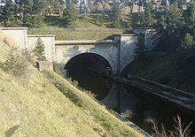
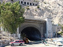
The Tunnel du Rove is a formerly navigable canal tunnel built between 1911 and 1927 and part of the Canal de Marseille au Rhône shipping canal . The tunnel crosses under the Estaque Mountains and is named after the small town of Le Rove . The tunnel is located in the south of France, in the Provence-Alpes-Côte d'Azur region .
The tunnel has been closed to traffic since a partial collapse on June 17, 1963. The collapse left a crater 15 meters deep above ground near Gignac-la-Nerthe . The collapse site is about 5.4 km from the southeast portal (towards Marseille) and was structurally stabilized a few years ago. There are shafts to the surface on both sides of the collapse site. The thickness of the rock overlying the tunnel was originally between 35 and 45 meters in this area.
location
The tunnel begins in the port of Marseille ( Port de la Lave ). It is 7.12 kilometers long, 22 meters wide and 15.4 meters high. With a draft of four meters, it was navigable with ships up to 1,500 tons, which could also meet in the tunnel. In terms of dimensions, it is one of the largest shipping tunnels in the world. At Marignane it reappears and is connected to the Étang de Bolmon , a bay of the Étang de Berre , via an open stretch of canal 3.4 kilometers in length .
Coordinates
![]() Map with all coordinates: OSM | WikiMap
Map with all coordinates: OSM | WikiMap
- Southeast portal: 43 ° 21 ′ 35 ″ N , 5 ° 17 ′ 37.6 ″ E
- Northwest portal: 43 ° 23 ′ 58.5 ″ N , 5 ° 13 ′ 29.3 ″ E
- Collapse site: 43 ° 23 ′ 24.3 ″ N , 5 ° 14 ′ 27.8 ″ E
- western ventilation shaft: 43 ° 23 ′ 28 ″ N , 5 ° 14 ′ 23.3 ″ E
- Eastern ventilation shaft: 43 ° 23 ′ 23.2 ″ N , 5 ° 14 ′ 31.6 ″ E


