
Doux (river)
| Doux | ||
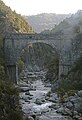
 Mouth of the Doux into the Rhône |
||
| Data | ||
| Water code | FR : V37-0400 | |
| location | France , Auvergne-Rhône-Alpes region | |
| River system | Rhone | |
| Drain over | Rhone → Mediterranean | |
| source | in the municipality of Saint-Bonnet-le-Froid 45 ° 8 ′ 13 ″ N , 4 ° 26 ′ 6 ″ E |
|
| Source height | approx. 1100 m | |
| muzzle | at Tournon-sur-Rhône in the Rhone coordinates: 45 ° 4 ′ 23 " N , 4 ° 49 ′ 38" E 45 ° 4 ′ 23 " N , 4 ° 49 ′ 38" E |
|
| Mouth height | approx. 361 m | |
| Height difference | approx. 739 m | |
| Bottom slope | approx. 11 ‰ | |
| length | 70 km | |
| Left tributaries | Daronne | |
| Right tributaries | Sumène , Grozon , Duzon | |
| Small towns | Tournon-sur-Rhône | |
The Doux is a French river that has its source in the Massif Central , in the Haute-Loire department , and then runs exclusively in the Ardèche department .
Run


Its source is located in the northern foothills of the Cevennes , in the municipality of Saint-Bonnet-le-Froid . It flows in a west-east direction towards the Rhône, into which it flows after 70 kilometers, as a right tributary, at Tournon-sur-Rhône . The river is dammed up several times to generate energy.
At the confluence of the Duzon in the Doux, a weaving mill was built around 1845 , which existed until 1990. It used the water power of the Doux, for this purpose a dam was built upstream .
In 1902, the Clauzel Dam was built on the isthmus of a river loop east of Saint-Barthélemy-le-Plain, called "Le Puy". The dammed water was channeled through the narrow passage, which was only approx. 50 meters wide and, thanks to the difference in gradient, drove the turbines of a small power plant, whose efficiency was soon recognized as too low. Therefore, between 1917 and 1920, an artificial canal was built from the reservoir to the new Mordane power plant two kilometers down the river. This canal largely follows the valley of the Doux on its northern slope, crosses the river twice on bridges and finally crosses under a hill in a river bend. It was built in part by German prisoners of war from the First World War , which is why it bears the name "Canal des Allemands" (Canal of the Germans).
Places on the river
Attractions
- The Gorges du Doux - the Doux is an attractive area for kayaking and canoeing, although the upper section of the river is only recommended for experienced paddlers
- The Pont Grand , a medieval bridge at the exit of the gorge in the municipality of Tournon-sur-Rhône
- The narrow-gauge museum train Train de l'Ardèche runs between Tournon-sur-Rhône and Lamastre on the route of the Tournon – Le Cheylard line parallel to the river
Gorges du Doux

Canal des Allemands and its upper bridge over the river, left the isthmus "Le Puy"

Barrage at Tournon – St.-Jean-de-Muzols


See also
Web links
Remarks
- ↑ a b geoportail.fr (1: 16,000)
- ↑ a b The information on the length of the river is based on the information about the Doux at SANDRE (French), accessed on January 27, 2012, rounded to full kilometers.
- ↑ Mémoires du 19ème et du 20ème siècle at st-barthelemyleplain.pagesperso-orange.fr, accessed on January 3, 2019