
Désaignes
|
Désaignes Desanha |
||
|---|---|---|
|
||
| region | Auvergne-Rhône-Alpes | |
| Department | Ardèche | |
| Arrondissement | Tournon-sur-Rhône | |
| Canton | Skin vivarais | |
| Community association | Pays de Lamastre | |
| Coordinates | 45 ° 0 ′ N , 4 ° 31 ′ E | |
| height | 380-1,170 m | |
| surface | 50.72 km 2 | |
| Residents | 1,111 (January 1, 2017) | |
| Population density | 22 inhabitants / km 2 | |
| Post Code | 07570 | |
| INSEE code | 07079 | |
| Website | http://www.desaignes.fr/ | |
 Town hall (Mairie) of Désaignes |
||

Désaignes ( Occitan : Desanha ) is a French municipality with 1,111 inhabitants (as of January 1 2017) in the department of Ardèche in the Region Auvergne Rhône-Alpes . The municipality belongs to the Arrondissement of Tournon-sur-Rhône and the canton of Haut-Vivarais . The inhabitants are called Désaignois .
geography
Désaignes is located on the Doux River . Désaignes is surrounded by the neighboring municipalities of Labatie-d'Andaure in the north, Nozières in the northeast, Lamastre in the east, Saint-Basile in the southeast, Saint-Prix in the south and Saint-Agrève in the south and west and Saint-Jean-Roure in the southwest.
Population development
| year | 1962 | 1968 | 1975 | 1982 | 1990 | 1999 | 2006 | 2013 |
| Residents | 1,672 | 1,482 | 1,284 | 1,182 | 1,087 | 1.105 | 1,154 | 1,129 |
| Source: Cassini and INSEE | ||||||||
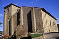
Attractions
- Catholic Church
- Protestant church with remains of the medieval castle
- Désaignes Castle from the 14th century
- Medieval gates

Gate of the castle complex

Catholic Church
Protestant Church


Personalities
- Conrad Kilian (1898–1950), geologist
Web links
Commons : Désaignes - collection of images, videos and audio files