Satillieu
|
Satillieu Satilhau |
||
|---|---|---|

|
|
|
| region | Auvergne-Rhône-Alpes | |
| Department | Ardèche | |
| Arrondissement | Tournon-sur-Rhône | |
| Canton | Skin vivarais | |
| Community association | Val d'Ay | |
| Coordinates | 45 ° 9 ' N , 4 ° 37' E | |
| height | 433-1,225 m | |
| surface | 32.82 km 2 | |
| Residents | 1,546 (January 1, 2017) | |
| Population density | 47 inhabitants / km 2 | |
| Post Code | 07290 | |
| INSEE code | 07309 | |
| Website | http://www.mairie-satillieu.fr/ | |
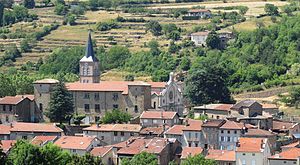
 View of Satillieu |
||
Satillieu ( Occitan : Satilhau ) is a French municipality with 1546 inhabitants (as of January 1 2017) in the department of Ardèche in the Region Auvergne Rhône-Alpes . Satillieu belongs to the Arrondissement Tournon-sur-Rhône and the Canton of Haut-Vivarais (until 2015: Canton Satillieu ). The inhabitants are called Satillien (ne) s .
geography
Satillieu lies on the Ay , into which the small rivers Nant and Malpertuis flow, about 16 km south-southwest of Annonay . Satillieu is surrounded by the neighboring communities of Saint-Alban-d'Ay in the north, Saint-Romain-d'Ay in the northeast, Préaux in the east, Vaudevant in the southeast, Pailharès in the south, Lafarre in the southwest, Lalouvesc in the west and southwest, Saint- Symphorien-de-Mahun in the west and Vocance in the northwest.
The former route nationale 578 runs through the municipality .
Population development
| year | 1962 | 1968 | 1975 | 1982 | 1990 | 1999 | 2006 | 2013 |
| Residents | 2,071 | 1,998 | 1,972 | 1,854 | 1,818 | 1,592 | 1,603 | 1,603 |
| Source: Cassini and INSEE | ||||||||
Attractions
- Saint-Priest church
- Rectory
- lock
- Historic town center

