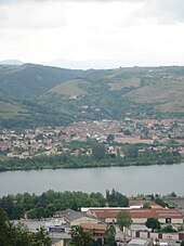
Sarras (Ardeche)
| Sarras | ||
|---|---|---|

|
|
|
| region | Auvergne-Rhône-Alpes | |
| Department | Ardèche | |
| Arrondissement | Tournon-sur-Rhône | |
| Canton | Sarras | |
| Community association | Porte de DrômArdèche | |
| Coordinates | 45 ° 11 ′ N , 4 ° 48 ′ E | |
| height | 121-402 m | |
| surface | 11.65 km 2 | |
| Residents | 2,199 (January 1, 2017) | |
| Population density | 189 inhabitants / km 2 | |
| Post Code | 07370 | |
| INSEE code | 07308 | |
| Website | www.sarras.fr | |
 Sarras Town Hall |
||
Sarras is a French commune with 2,199 inhabitants (as of January 1 2017) in the department of Ardèche in the Region Auvergne Rhône-Alpes . The municipality belongs to the Arrondissement of Tournon-sur-Rhône and the canton of Sarras (until 2015: Canton Tournon-sur-Rhône ).
geography
Sarras is located about 75 kilometers south of Lyon on the banks of the Rhone , into which the Ay river flows. In the north, the Cance limits the community. Sarras is surrounded by the neighboring communities Talencieux and Andance in the north, Laveyron in the northeast, Saint-Vallier in the east and southeast, Ozon in the south, Eclassan in the southwest and Ardoix in the west and northwest.
The Saint-Joseph wine is produced in the Côtes du Rhône wine-growing region , to which the municipality also belongs .
Population development
| year | 1962 | 1968 | 1975 | 1982 | 1990 | 1999 | 2006 | 2012 |
| Residents | 1,518 | 1,555 | 1,660 | 1,669 | 1,837 | 1,829 | 1,992 | 2,072 |
| Source: Cassini and INSEE | ||||||||
Attractions
- Church, originally built in the 12th century, today's church building from 1860
- Chapel from 1874
- Sarras Castle (Revirand, Carret and Sarras Castles)
- fortified gate from 1550
- Fountain from 1867

