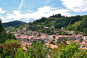
Le Cheylard
| Le Cheylard | ||
|---|---|---|

|
|
|
| region | Auvergne-Rhône-Alpes | |
| Department | Ardèche | |
| Arrondissement | Tournon-sur-Rhône | |
| Canton | Haut-Eyrieux | |
| Community association | Val Eyrieux | |
| Coordinates | 44 ° 54 ' N , 4 ° 25' E | |
| height | 404-927 m | |
| surface | 13.45 km 2 | |
| Residents | 2,952 (January 1, 2017) | |
| Population density | 219 inhabitants / km 2 | |
| Post Code | 07160 | |
| INSEE code | 07064 | |
| Website | www.ville-lecheylard.fr | |
 Place view |
||
Le Cheylard is a French commune with 2,952 inhabitants (at January 1, 2017) in the department of Ardèche in the Region Auvergne Rhône-Alpes . It belongs to the Val Eyrieux municipal association and is its administrative seat. Its inhabitants are called Cheylarois (es) .
geography
The city extends in the center of the Massif Central in the Ardèche department. It is part of the Monts d'Ardèche Regional Nature Park . The Dorne flows into the Eyrieux within the village .
Population development
| year | 1962 | 1968 | 1975 | 1982 | 1990 | 1999 | 2007 | 2016 |
| Residents | 3735 | 3979 | 4262 | 4239 | 3833 | 3514 | 3313 | 2991 |
| Sources: Cassini and INSEE | ||||||||
Attractions
- Château de La Chèze, castle from the 14th century
- Old town
- Church of the Assumption
traffic
railroad
In Le Cheylard there was a train station of the Chemin de Fer Departementaux (CFD) from 1893 to 1968 . From here meter gauge routes led to Tournon-sur-Rhône , La Voulte-sur-Rhône (at the mouth of the Eyrieux into the Rhône) and Dunières . Le Cheylard was the seat of the central workshop and the administration of the meter-gauge railway network in Vivarais.
Road connection
Department roads D518 and D120 intersect in Le Cheylard . The former leads from Aubenas via Vals-des-Bains and Mezilhac to Lamastre and Annonay over the Col de Nonières pass , the latter from La Voulte-sur-Rhône to Saint-Agrève and on to Le Chambon-sur-Lignon.
Partner communities
- Weilmünster in Hessen, Germany
