
Realp
| Realp | |
|---|---|
 |
|
| State : |
|
| Canton : |
|
| District : | No district division |
| BFS no. : | 1212 |
| Postal code : | 6491 |
| Coordinates : | 681.58 thousand / 161 399 |
| Height : | 1538 m above sea level M. |
| Height range : | 1498–3583 m above sea level M. |
| Area : | 77.84 km² |
| Residents: | 153 (December 31, 2018) |
| Population density : | 2 inhabitants per km² |
|
Proportion of foreigners : (residents without citizenship ) |
6.3% (December 31, 2,014) |
| Mayor : | Armand Simmen |
| Website: | www.realp.ch |
 Realp from the southwest |
|
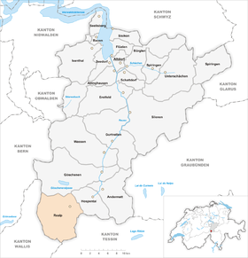
| Location of the municipality | |
  |
|
Realp [ˈrealp] , Urnerdeutsch [ˈreialp] or older [frɪ'alp] , is a municipality in the Swiss canton of Uri .
geography
The place is at the western end of the Urseren high valley at the foot of the Furka Pass on the left bank of the Furkareuss . In addition to the village, the municipality also has a few alpine settlements and individual farms. The most important of them is Tiefenbach ( 2106 m above sea level ). For a long time, Realp was the municipality in Switzerland most at risk from avalanches .
Only 50 hectares or 0.6% of the municipality is settlement area. Of this, 7 hectares are buildings and 41 hectares are traffic areas. The agricultural area is more extensive with 3243 hectares or a share of 41.6%. Among them are large alpine areas. These cover an area of 3116 ha. Only 117 ha are meadow and arable land. Due to its high location, only 182 hectares or 2.3% are covered by forest and wood. Unproductive area comprises a large part of the municipal area, namely 4321 ha or 55.4%. It concerns almost exclusively areas without vegetation (high mountains) or areas with unproductive vegetation (high alpine vegetation).
Realp borders in the west on the Valais community of Obergoms , in the north on Göschenen , in the east on Hospental and in the south on the Ticino communities Airolo and Bedretto .
population
Residents
The population fluctuated between 1850 and 2010 from 180 to 230 residents. The only higher numbers were in 1941, 1960 and 1980. Between 1980 and 2000 there was greater emigration. The lowest population level was recorded in 2000 with just 146 people. The highest number of inhabitants ever counted was 308 in 1980. Since 2000 the number of inhabitants has increased again slightly.
The main genders in Realp are: Nager, Renner, Simmen and Cathry. One of the best known citizens of Realp was corps commander Franz Nager (1896–1976).
| Population development | |||||||||||||||||
|---|---|---|---|---|---|---|---|---|---|---|---|---|---|---|---|---|---|
| year | 1799 | 1850 | 1880 | 1888 | 1900 | 1941 | 1950 | 1960 | 1970 | 1980 | 1990 | 2000 | 2005 | 2010 | 2012 | 2014 | 2016 |
| Residents | 170 | 203 | 232 | 193 | 208 | 242 | 186 | 268 | 205 | 308 | 181 | 146 | 161 | 144 | 133 | 143 | 145 |
languages
At the last census in 2000, 100% stated German as their main language. In everyday life, the population speaks the highest Alemannic Urschelertytsch .
Religions - denominations
In 2000, 142 people were Roman Catholics, making up 97% of the total population; 3% were Protestant Reformed.
Origin - nationality
At the end of 2005, 154 (96%) of the 161 residents were Swiss citizens. The few immigrants come from Germany and Croatia. At the 2000 census, 145 people (99%) were Swiss citizens; three of them had dual citizenship.
age structure
The community has a high proportion of older residents. The proportion of people under the age of twenty is 14.38% of the local population and is thus significantly below the proportion of people of senior age (60 years and older: 31.51%).
The last census in 2000 showed the following age structure:
| Age | 0–6 years | 7-15 years | 16-19 years | 20-29 years | 30–44 years | 45–59 years | 60–79 years | 80 years and more |
|---|---|---|---|---|---|---|---|---|
| number | 5 | 15th | 1 | 16 | 25th | 38 | 39 | 7th |
| proportion of | 3.42% | 10.27% | 0.68% | 10.96% | 17.12% | 26.03% | 26.71% | 4.79% |
politics
legislative branch
The municipal assembly forms the legislature . It usually meets twice a year.
executive
The seven-member municipal council forms the executive . He works part-time. Current mayor is Armand Simmen (as of 2017).
economy
With the dismantling of the Gotthard fortress from 1985, Realp lost numerous jobs. In 2005 there were five farms offering eight jobs. There were no industrial or commercial enterprises, and the service sector employed 63 people in 16 enterprises (employment converted to full-time positions). The 2000 census had revealed six agricultural and forestry businesses with 13 employees. In 2001 there were 67 employees in 18 service companies. Of Realp's 67 gainfully employed persons in 2000, 33 (49.25%) worked in their own community. In total, the place offered work to 47 people, of whom 33 (70.21%) were locals.
Most of the 34 commuters do their work in other communities in the canton of Uri. Including 25 people in Andermatt and four in Altdorf . There were only 14 commuters. These came mainly from the other Urseren communities Andermatt and Hospental.
traffic

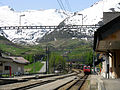
The community is located on the Furkapassstrasse. The closest motorway connection is Göschenen on the A2 . In terms of rail technology, the community is better located thanks to the Matterhorn-Gotthard-Bahn and its predecessor, the Furka-Oberalp-Bahn . The east portal of the Furka base tunnel ( car transport ) is located near the Realps train station . From Realp, the Furka mountain line steam train (museum train) leads to Gletsch and Oberwald .
history

The name goes back to the Latin rīvum album , which means “white stream” (“white” means the whitish melt water of the Reuss). It is an original name of the water body, which was only transferred to the village in a secondary manner. The first written mentions date from 1331 ( prope Reandum, copy of the 14th century) and from February 7, 1363 (from Riealb) . The older dialect minor form Frealp, Frialp arose from the connection uf Realp "auf (in) Realp".
The originally Romanesque settlement was Germanized in the 12th century by Walsers who immigrated from the Valais . In the Middle Ages, the place was part of the Ursern valley community. In 1882 Realp became a parish independent of Andermatt; In 1888, the Uri cantonal constitution recognized Realp as an autonomous political municipality. In 1926 Realp became a station on the Furka-Oberalp Railway.
On his second trip to Switzerland, Johann Wolfgang von Goethe reached the village of Realp on November 12, 1779 "at nightfall" in order to climb the St. Gotthard , where he stayed for three nights with the Capuchins.
Attractions

At Realp train station

Realp, center with Roman Catholic. Church and Hotel «Post»

Furka mountain route steam train
Realp loading station

Avalanche protection wall in Realp

Rescue station: Furka tunnel in Realp with the locomotive of the rescue train

Car train in Realp towards Valais through the Furka base tunnel


literature
- Thomas Brunner: The art monuments of the canton Uri, Volume 4: Upper Reuss Valley and Urseren. Edited by the Society for Swiss Art History GSK. Bern 2008 (Art Monuments of Switzerland Volume 114). ISBN 978-3-906131-89-4 , pp. 416-447.
- Hans Stadler: Realp. In: Historical Lexicon of Switzerland . 2010 .
Web links
- Realp on the ETHorama platform
- Official website of the municipality of Realp (including tourist office)
Individual evidence
- ↑ Permanent and non-permanent resident population by year, canton, district, municipality, population type and gender (permanent resident population). In: bfs. admin.ch . Federal Statistical Office (FSO), August 31, 2019, accessed on December 22, 2019 .
- ↑ https://www.pxweb.bfs.admin.ch/Selection.aspx?px_language=de&px_db=px-x-0102020000_201&px_tableid=px-x-0102020000_201\px-x-0102020000_201.px&px_type=PX
- ↑ a b Lexicon of Swiss municipality names . Edited by the Center de Dialectologie at the University of Neuchâtel under the direction of Andres Kristol. Frauenfeld / Lausanne 2005, p. 727 f.
- ↑ Emil Abegg : The dialect of Urseren. Huber, Frauenfeld [1911] (Contributions to Swiss German Grammar IV), p. 1.
- ↑ See family name book of Switzerland .
- ↑ See Emil Abegg : The dialect of Urseren. Huber, Frauenfeld [1911] (Contributions to Swiss German Grammar IV).
Altdorf | Andermatt | Attinghausen | Build | Bürglen | Erstfeld | Flüelen | Göschenen | Belt pins | Hospental | Isenthal | Realp | Schattdorf | Seedorf | Seelisberg | Silenen | Sisikon | Spiringen | Undercuts | Water
Canton of Uri | Districts of the canton Uri | Municipalities of the Canton of Uri