
Unicorn
| Unicorn | ||
|---|---|---|
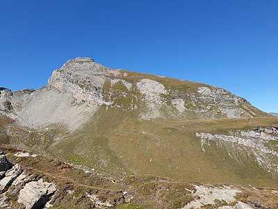
 View from Hinterrhein GR to the Einshorn |
||
| height | 2944 m above sea level M. | |
| location | Canton of Graubünden , Switzerland | |
| Mountains | Adula Alps | |
| Dominance | 4.03 km → Piz de la Lumbreida | |
| Notch height | 571 m ↓ Strec de Vignun | |
| Coordinates | 737 483 / 153220 | |
|
||
.jpg) Steinmann on the unicorn |
||

The Einshorn is a mountain south of Nufenen in the canton of Graubünden in Switzerland with an altitude of 2944 m above sea level. M.
Location and surroundings
_Spherical_Panorama.jpg)
The Einshorn belongs to the Adula Alps and lies between the Misox , the Rheinwald and the Val Curciusa . The 2944 m high summit is located on the border between the municipal areas of Rheinwald and Mesocco . The mountain is also called Gadriolhorn, Piz Gadriol, Schwarzhorn or Mittagshorn.
Its neighboring peaks include the Guggernüll ( 2886 m ), the Piz Cavriola ( 2871 m ), the Piz Uccello ( 2724 m ), the Mittaghorn ( 2364 m ), the Piz de la Lumbreida ( 2983 m ) or the Pizzo Tambo ( 3279 m ).
The most distant visible point ( 44 ° 10 ′ 42.7 ″ N , 7 ° 37 ′ 52.3 ″ E ) of the Einshorn is located around 40 km southeast of Cuneo in the Italian region of Piedmont , just before the border with France and is 289 km away.
Valley locations are Nufenen and Hinterrhein , frequent starting points are Nufenen and San Bernardino .
Origin of name
Once upon a time, the time when the sun went over or behind a mountain gave rise to naming a peak, e.g. B. midday horn, twelve horn, unicorn. This is what happens at the Einshorn south of Tschappina in the canton of Graubünden, which is 20 kilometers (as the crow flies) northeast of the Einshorn near Nufenen. The 2457 m high summit lies between the Piz Beverin ( 2998 m ) and the Zwölfihorn ( 2292 m ) and is described as a "mountain peak over which the sun stands at 1 o'clock" ( Andrea Schorta : How the mountain got its name) . Accordingly, the Einshorn near Nufenen owes its name to the position of the sun.
In the immediate vicinity of the Einshorn near Nufenen there is also a horn that owes its name to the position of the sun: the Mittaghorn. The use of noon - as opposed to Eins or Zwölfi - was used more frequently in naming. In addition to several midday horns, there are also midday spitz, midday gaps or midday sticks , for example .
Routes to the summit
Summer routes
Over the east ridge
- Starting point: Nufenen ( 1569 m )
- Via: Alp de Rog ( 1810 m ), La Valeten
- Difficulty: EB
- Time required: 4½ hours
Through the southern flank
- Starting point: San Bernardino ( 1608 m ) or San Bernardino Pass ( 2066 m )
- Via: Strec de Vignun ( 2372 m ), La Valeten
- Difficulty: EB
- Time required: 3¾ hours from San Bernardino, 4¾ hours from the San Bernardino Pass
Over the northwest pillar
This route is not recommended.
- Starting point: Nufenen ( 1569 m ) or Hinterrhein ( 1620 m )
- Via: Alp Cadriola ( 1962 m )
- Difficulty: S, SS
- Time required: 8¼ hours
Over the north ridge
The north face is avoided by climbers for good reasons.
- Starting point: Nufenen ( 1569 m )
- Via: Horneralp
- Difficulty: S
- Time required: 8 hours from Nufenen, 6 hours from the entrance
Through the northeast face
The two couloirs through the north-eastern summit wall are filled with loose material, interrupted by delicate steps and therefore hardly passable.
- Starting point: Nufenen ( 1569 m )
- Via: Horneralp
- Difficulty: WS
- Time required: 4½ hours from Nufenen
Winter routes
The Einshorn can be tackled in absolutely safe snow and weather conditions and by experienced ski mountaineers.
From Nufenen
- Starting point: Nufenen ( 1569 m )
- Via: Alp de Rog ( 1810 m )
- Exposures: W, E, SE
- Difficulty: S-
- Time required: 6 hours
From San Bernardino
- Starting point: San Bernardino ( 1608 m )
- Via: Strec de Vignun
- Exposures: S, E
- Difficulty: S-
- Time required: 6 hours
Descent with an ascent to P. 2862 to San Bernardino
- Destination: San Bernardino ( 1608 m )
- Via: P. 2862, Val Vignun
- Exposures: S, E, SW
- Difficulty: S-
panorama
_Panorama.jpg)
gallery

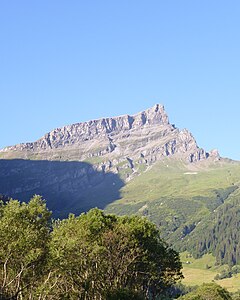
Einshorn, recorded by Splügen .
Unicorn, taken from the southeast.
Unicorn, taken from the northeast.

_as_seen_from_South-East.jpg)

literature
- Vital Eggenberger: Ski touring North Grisons . Verlag des SAC, 2008, ISBN 978-3-85902-270-6 , p. 344-346 .
- Manfred Hunziker: Club guide, Bündner Alps . Obverse. 1st edition. tape III . Verlag des SAC, 1994, ISBN 3-85902-140-0 , p. 45-47 .
Web links
- Calculated 360 ° panorama from the Einshorn
- Tour reports on www.hikr.org
Individual evidence
- ^ Peter Hug: Geographical Lexicon of SWITZERLAND . tape 1 . Verlag von Gebrüder Attinger, Neuchâtel 1902, p. 688 ( peter-hug.ch [accessed April 10, 2020]).
- ↑ Calculated 360 ° panorama ( U. Deuschle ; notes ) from the Einshorn
- ↑ Julius Studer: Swiss place names: historical - ethmological . BoD - Books on Demand, 2015, ISBN 978-3-95656-281-5 , pp. 42 .
- ↑ Andrea Schorta: How the mountain got its name . Small Rhaetian name book with two and a half thousand geographical names of Graubünden. Terra Grischuna Verlag, Chur and Bottmingen / Basel 1988, ISBN 3-7298-1047-2 , p. 84 .
- ^ Manfred Hunziker: Club guide, Bündner Alps . Obverse. 1st edition. tape III . Verlag des SAC, 1994, ISBN 3-85902-140-0 , p. 46 .
- ^ Manfred Hunziker: Club guide, Bündner Alps . Obverse. 1st edition. tape III . Verlag des SAC, 1994, ISBN 3-85902-140-0 , p. 46 .
- ^ Manfred Hunziker: Club guide, Bündner Alps . Obverse. 1st edition. tape III . Verlag des SAC, 1994, ISBN 3-85902-140-0 , p. 47 .
- ^ Vital Eggenberger: Ski touring North Grisons . Verlag des SAC, 2008, ISBN 978-3-85902-270-6 , p. 344 .