Schnebelhorn
| Schnebelhorn | ||
|---|---|---|
|
View from Lipperschwendi in the Töss Valley to the Schnebelhorn |
||
| height | 1291.9 m above sea level M. | |
| location | Canton border Zurich / St. Gallen , Switzerland | |
| Dominance | 3.02 km → Höchhand | |
| Notch height | 113 m ↓ saddle between Schindelegg and Rossegg | |
| Coordinates | 716 481 / 242787 | |
|
|
||
| particularities | highest mountain in the canton of Zurich | |
|
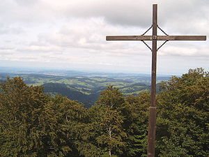
Summit cross, looking towards the lower Toggenburg |
||
The Schnebelhorn is 1292 m above sea level. M. the highest peak in the canton of Zurich in Switzerland . The summit lies on the canton border between the canton of Zurich and the canton of St. Gallen . The panoramic view extends over the Zurich Oberland , Lake Zurich and Greifensee in the west and over the Toggenburg in the east.
The Schnebelhorn is a popular destination for hikes. It is accessible from both sides, from the Töss Valley and the Thur Valley. The most frequented hiking trail is the Höhenweg from the Hulftegg ( 953 m above sea level ).
With a very broad definition, the Schnebelhorn is a secondary peak of the Tweralpspitz , as the mountain ranges connect all the peaks in the region and the Tweralpspitz is the highest of all - but between the Schnebelhorn and the Tweralpspitz there are five other small peaks on the at least 5 kilometers (Beeline) long ridge.


