
St. Luzisteig fortress


The fortress St. Luzisteig was a defensive position of the Swiss army . It is located on the St. Luzisteig pass at 713 m above sea level in the canton of Graubünden and was part of the Sargans fortress . The Luzienstig is considered the most contested place in Switzerland and the fortress is a military-historical monument of national importance.
history
St. Luzisteig was already used as a transition and settlement site in prehistoric times. From the Roman era to the 19th century, the road on the right bank of the Rhine was the main connection on the north-south axis. The bottleneck behind the Fläscherberg played a central role as a strategically important transition ( passage obligée ) in the great disputes in European history .
The fortress St. Luzisteig is located near the state border on the Maienfeld - Vaduz road and blocked northern access to the Bündnerland and the Bündner passes. The remains of the land wall / Letzi Grafenberg at the foot of the ruins of Grafenberg Castle date from the 15th century. In the Swabian War of 1499 this Letzi was fought over.

During the Graubünden turmoil from 1618 to 1639, the invading Austrians and French built extensive facilities there. The fortress, which was destroyed by Austrian troops under Colonel Brion in 1621, was rebuilt in 1622, again in the possession of the Bündner, according to plans by the Zurich builder, Captain Johannes Ardüser . The still visible «Kleine Schanze» ( Redoute ) at the top of the pass had the Duke of Rohan built around 1631 .
On behalf of the Graubünden government, a baroque fortress was built from 1703 to 1705 according to plans by the Zurich fortress master builder Hans Caspar Werdmüller , as the medieval fortifications could no longer withstand the effects of the new guns: a brick front was built across the Passsattel as well as a Wall, which, as a sawmill, connected the main front with the Guscha battery on the right slope of the valley. A similar wall was built north in the valley between the Rhine and the rocky slope of the Fläscherberg.
In October 1798 Austrian troops under the command of Franz Xaver von Auffenberg reinforced the team of the three leagues . The Republic of the Three Leagues had formally asked Austria for help in the fight against the Helvetic Republic and France . This was preceded by a nationwide referendum on August 6, 1798. On March 5, 1799 , French troops under General André Masséna attacked the fortress coming from Balzers and defeated the Austrian team. 800 soldiers were taken prisoner. Parts of the fortress were destroyed in the fight. On May 14, 1799, General Friedrich von Hotze managed to recapture the fortress for Austria from Feldkirch . In October 1799 the defeated Russian army of General Vasilyevich Suvorov used the St. Luzisteig for his retreat. In September, he had successfully crossed the Gotthard Pass, coming from Italy, in order to stab the French in the back and to unite his army with that of General Rimski-Korsakow and Hotze. But the plan didn't work out and he went from hunter to hunted. He had to get over Uri, Schwyz, the Pragelpass , Glarus, the Panixerpass into the Bündnerland. 15,000 men reached the fortress on October 12, completely exhausted, and had to be fed. They then continued to Feldkirch via Liechtenstein.
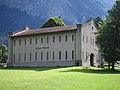
After the chief of staff Guillaume-Henri Dufour declared in his report of 1831 the repair of the fortifications ( Dufour fortifications ) of Gondo , Saint-Maurice , Aarberg and on the Luzisteig as an urgent task, the old bastion front from the 18th century became that same year rebuilt as the center of the fortress by a Bernese sapper company under the Chur captain of genius and engineer Richard La Nicca and a new fortress was built on the St. Luziensteig. A lunette (throat front barracks) with a front facing Maienfeld was created to cover the back .
In the 1850s, the log houses were built on the Fläscherberg under the direction of General Henri Dufour to prevent bypassing the left flank. An armory / log house was built on the top of the pass. During the Crimean War , a rifle tower ("Gusha" or "Hunger tower") was built near the Gusha battery, including a barrier wall through the Gushawald. Due to its elevated position, the «Guschaturm» allowed long-distance reconnaissance. During these years all barracks and casemates, the elevation of the ramparts, the glacis system , the «Battery Herzog» artillery position and the Fläscherberg Felsweg with rifle gallery were built. In the northern plain, works were created between Ellwand and Rhine.
According to the plans of the engineer-officer courses from 1934 to 1936, this blocking point should be massively expanded. Tank barricades were built in 1937, followed by further bunkers and caverns , fortifications and the barracks building B.
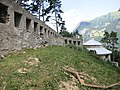
From 1994 to 2005, based on the concept of Peter Zumthor, three elongated two-storey flat roof buildings made of concrete (troop accommodation, catering and canteen) and later a control center building to the west were built east of the cantonal road. This was followed by restoration and renovation of the historic buildings and walls from the 19th century.
In addition to the infantry and combat training of Luzisteig 1964-2003 apprenticeship was Train troops . With Army XXI , the train left the Luzisteig arsenal. Since 1995 the St. Luzisteig military training area has belonged to the Walenstadt / St. Luzi dough.
Historical fortifications

- Gatehouse 1703 ⊙
- Casematte D 1859 ⊙
- Casematte E 1859 ⊙
- Casematte F1 1859 ⊙
- Casematte F2 1859 ⊙
- Casematte F3 battery, later forge 1917 ⊙
- Stable accommodation 1880 ⊙
- Ammunition magazine / battery Herzog 1859 ⊙
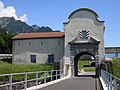
Gatehouse 1703
Casematte E F1-F3 1859

Stables 1880

Casematte D 1859

Battery Herzog 1859


Historic outdoor facilities
- Letzimauer Grafenberg ⊙
- Small ski jump Luzisteig (Redoute) ⊙
- Military museum, former armory / blockhouse 1859 ⊙
- Rifle Gallery Felsenweg ⊙
- Barrier wall ⊙
- Guschaturm 1853-55 ⊙
- Guschamauer ⊙
Small hill
Military Museum / Arsenal 1859

Rifle Gallery Felsenweg
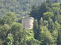
Guschaturm

Guschamauer with Guschaturm


- Blockhouse Zwingli 1859 ⊙
- Log cabin Naville 1859
- Log house M 1859 ⊙
- Log house S 1859 ⊙
- Log house B 1859 ⊙
- Log house E 1859 ⊙
- Blockhouse G 1859 ⊙

Log cabin Z

Log house N
Log house B

Log house E

Log cabin G


Lock point St. Luzisteig
The St. Luzisteig blocking point (Army designation no. 1317) was created during the Second World War and the Cold War (until 1965). It extended from the fortress St. Luzisteig to the south over the southern descent to Fläsch and concentrated on the traffic axis that runs from the north (Liechtenstein).
- Terrain tank obstacle GPH Steigstrasse Nord ⊙
- Infantry bunker Luzisteig A 6213 2 Ik / Pak, 2 Mg ⊙
- GPH Steigstrasse Süd ⊙
Artillery works Römerstrasse
The artillery works Römerstrasse (army designation A 6212) is a rock that lies to the west above the fortress St. Luzisteig. The cavern position in the north wall of the Persaxplatten was blown up around 1942 for the artillery of the Luziensteig combat group. The plant is located on the old fortress path on the Fläscherberg. The large notches were placed below the path. This artillery worked in front of the Ansstein - Schollberg barrier . The infrastructure was limited to an ammunition magazine, the barracks provided accommodation.
In 1943 the motor cannon battery 95, which had emerged from the mountain battery 202, with its 7.5 cm field cannons, moved into the factory. In 1947 these were replaced by permanently installed 12 cm howitzers and a shooting range was installed. In the absence of a ventilation system, the guns were equipped with a blowout device. Around 1962 the factory excavated a tunnel and a cavern for the battalion command post A 6214. The artillery plant was abandoned around 1971 and disarmed in 1985.
The open gun stands at Obere Römerstrasse on the Fläscherberg north of the Schnielskopf were occupied by the motor cannon battery 96 in 1943. The guns had to be dismantled for transport. They were provided with parapets and concrete bedding and camouflaged as wooden huts. The firing directions corresponded roughly to those of the artillery plant. They were covered up in the 1980s and individual remains can still be found.
- Artillery cavern Römerstrasse A 6212 12 cm Hb 1 ⊙
- Artillery cavern Römerstrasse A 6212 12 cm Hb 2 ⊙
- Artillery cavern Römerstrasse A 6212 12 cm Hb 3 ⊙
- Artillery cavern Römerstrasse A 6212 12 cm Hb 4 ⊙
- Open artillery position Obere Römerstrasse 1 ⊙
- Open artillery position Obere Römerstrasse 2 ⊙
- Open artillery position Obere Römerstrasse 3 ⊙
- Open artillery position Obere Römerstrasse 4 ⊙

Felsenweg with artillery works A 6212

Notches A 6212

Terrain tank obstacle Luzisteig North

Infantry bunker World War II and Cold War


Museum and meeting place
The Military Historical Foundation Grisons was the old Arsenal (Arsenal) take over at the summit and set up a museum in it.
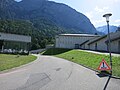
The former mountain station of the military cable car MSB106 Fläsch-Fläscherberg, which was closed in 1985, was converted into a public multi-purpose room by the municipality of Fläsch in 2010.

Fortress information board

Mountain station of the military cable car MSB106 Fläsch-Fläscherberg


literature
- Frank, captain in the Austrian quartermaster staff: A description of the Luziensteig fortress from 1834 . Bündnerisches monthly newspaper, magazine for Bündnerische history, Landes- und Volkskunde, volume 1943, issue 1
- Jakob Becher: Sketches on the history and appreciation of St. Luzisteig , Chur 1893.
- Theophil spokesman von Bernegg : From the history of Luzisteig , Chur 1934.
- Silvio Keller, Maurice Lovisa, Thomas Bitterli: Military monuments in the canton of Graubünden. Federal Department of Defense, Civil Protection and Sport (Ed.), Bern 2003
- Thomas Huber: Luzisteig training place for the train schools , manuscript 2005.
- Peter Baumgartner, Hans Stäbler: Fortified Graubünden. Wolves in sheep's clothing. Military History Foundation Graubünden, Chur 2006 ISBN 978-3-85637-321-4 . Extended edition Verlag Desertina, Chur 2016, ISBN 978-3-85637-485-3 .
- Inventory of historical traffic routes in Switzerland, status 1999: Route GR 1.5 “Deutsche Strasse” or “Reichsstrasse” over the St. Luzisteig
Web links
- St.Luzisteig Military Museum
- Municipality of Maienfeld 2012: A historical outline of the St.Luzisteig and the Waffenplatz
- Urs von Tobel, observer: Train. The planners are backing the wrong horse with the tanks
Individual evidence
- ^ Silvio Keller, Maurice Lovisa, Thomas Bitterli: Military monuments in the canton of Graubünden . Federal Department of Defense, Civil Protection and Sport (Ed.), Bern 2003
- ↑ W. Burkart: The Matluschkopf and the Felsabri near Prasax, municipality of Fläsch. A contribution to the prehistory of St. Luzisteig. Bündnerisches monthly newspaper, volume 1948, issue 3
- ^ Adolf Collenberg Istorgia Grischuna, page 203
- ^ Neue Zürcher Zeitung, The Gotthard becomes a European battlefield in autumn 1799.
- ^ Historical Lexicon of Switzerland Alexander Suworow
- ^ Peter Baumgartner, Hans Stäbler: Fortified Graubünden. Wolves in sheep's clothing. Military History Foundation Graubünden, Chur 2006.
- ↑ Oberland Fortress: Luzisteig GR
- ↑ Oberland Fortress: A6212 Artillery Works Römerstrasse GR
- ↑ NZZ of March 20, 2011: The multi-purpose room is in the mountain station
- ^ Community of Fläsch: meeting place Fläscherberg
- ^ Fortress Oberland: military cable car
- ↑ Burgenverein Untervaz: Fortified Graubünden 1941
Coordinates: 47 ° 2 '17.1 " N , 9 ° 31' 39.6" E ; CH1903: 758754 / two hundred eleven thousand seven hundred and eighty-four