
Kaiseregg
| Kaiseregg | ||
|---|---|---|
 The Kaiseregg, local mountain of the Sense Oberland |
||
| height | 2185 m above sea level M. | |
| location | Canton of Friborg , Switzerland | |
| Mountains | Freiburg Pre-Alps | |
| Dominance | 1.64 km → Rotenchaste | |
| Notch height | 200 m ↓ unnamed notch | |
| Coordinates | 590 855 / 166 814 | |
|
||
| rock | limestone | |

The Kaiseregg is a 2185 m high mountain in the Swiss canton of Friborg . It is part of the Freiburg Pre-Alps and is located in the municipality of Plaffeien ( Sense District) in the Schwarzsee district . The district border with the Gruyère district (municipality of Jaun ) runs a little west of the summit , and the canton border with the canton of Bern (municipality of Boltigen ) runs a little to the east .
The Schwarzsee (Lac Noir) to the west of the Kaiseregg is often the starting point for a hike up this mountain. The first meters in altitude can also be saved with the Riggisalp chairlift . It is one of the Kaiseregg lifts that open up the northwest flank with a chairlift and ski slopes in winter . The first ski lift on the Kaiseregg dates back to 1956, the second to the right of the first followed 7 years later. In summer 2011 the two ski lifts were replaced by a detachable 4-seater chairlift.
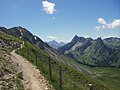
Way to the Kaiseregg

View towards the southwest


Web links
Individual evidence
- ↑ Schwarzsee / Kaiseregg - last ride on www.bergbahnen org. Retrieved December 30, 2011.