
High winds
| High winds | ||
|---|---|---|
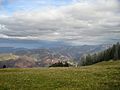
 East side of the Hohe Winde with Oberbeinwil in the foreground |
||
| height | 1204 m above sea level M. | |
| location | Canton of Solothurn | |
| Mountains | law | |
| Dominance | 2.24 km → Stierenberg | |
| Notch height | 153 m ↓ Scheltenpass | |
| Coordinates | 610 663 / 243556 | |
|
||

The high wind is a 1204 m above sea level. M. high mountain in the Swiss Jura .
It is located in the canton of Solothurn , municipality of Beinwil SO , between the valley of the Lüssel ( Passwangstrasse ) and the Guldental near the Schelten Pass .
The view stretching from the Vosges and the Black Forest to the Valais Alps makes the mountain, accessible via the Passwangstrasse and various hiking trails, a popular destination for excursions in the region. On a clear day, from the north side of the Chasseral , Elsässer Belchen (French: Ballon d'Alsace), the city of Basel , the Feldberg (D) , Rheinfelden (CH) , Wasserfallen (the terminus of the Wasserfallenbahn ), Passwang and south of the whole Alpine panorama can be seen.
Facilities
The ski hut of the Thierstein ski club is located near the summit. The hut is open on weekends and is accessible and catered for everyone. East of the summit is the restaurant "Vorder Erzberg" at an altitude of 1070 m, which can be reached by vehicle via the Scheltenpass road.
On the north side, above Beinwil-Schachen, there is a 1320 m long ski lift built in 1975 and several ski slopes.
history
In the Middle Ages, Bohner ore was mined near the summit . Dolines in the "Vorder Erzberg" area still bear witness to this today.
Meadow on the summit. View towards Wasserfallen and Passwang.
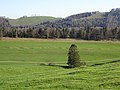
In the center of the picture, horizontal: Evidence of earlier iron ore mining


literature
- Markus Gasser: The high winds: history and stories . 2nd edition Münchenstein: Distribution: Interrepro, 2004. ISBN 3-9522454-0-2