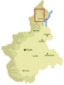
Ossola Valley

The Ossola Valley (in Italian Val d'Ossola, historically German Eschental ) is the valley of the Toce (German Tosa ) in the northern Italian region of Piedmont .
From the source at the Griespass on the Swiss border, the Toce first flows through the Pomatt ( Valle Formazza in Italian ). From the village of Premia Chioso to the tributary of the Diveria between Crevoladossola and Domodossola coming from the Simplon Pass , the Toce flows through the Antigorio Valley . From there to the mouth of the river in Lake Maggiore near Fondotoce , the valley is finally called Val d'Ossola .
The mountains between the Ossola valley in the west and Lake Maggiore in the east are home to the Val Grande National Park . Since this barely populated area has no general name, it is occasionally included in the wider sense of the Ossola Valley.
description
In the west, the mountains from Monte Leone via the Helsenhorn to the Blinnenhorn form the border with the Swiss canton of Valais . The Albrunpass provides the transition to the Valais Binntal . In the east, Baseldinerhorn (Italian Basodino ), Wandfluhhorn (Italian Pizzo Bièla ) and Sonnenhorn (Italian Pizzo Quadro ) form the border with the canton of Ticino .
The valley used to be an important traffic route, with a mule track leading from Valais over the Gries Pass to Lombardy and from Central Switzerland over the Gotthard Pass and Passo San Giacomo . In connection with the Grimsel Pass , this route was also important for trade between the Bernese Oberland and northern Italy.
In the Middle Ages, the Pomatt , south of it in the Valle Antigorio, the hamlets Salecchio (Walser German: Saley ), Agaro (Walser German: Áger) and Ausone (Walser German: Opsu) - the latter three today belong to the municipality of Premia - and to the east bordering Bosco / Gurin in Ticino Populated by Walsers and therefore German-speaking. Numerous German field names remind of this to this day. The Ashen valley was occupied twice by the Valais and the Swiss and was subsequently a common rule . After the Battle of Marignano in 1515, the Swiss had the valley to the time of France dominated Duchy of Milan cede.
In 1944, anti-fascist partisans established the independent Repubblica dellOssola in Val d'Ossola and the adjacent Val Grande for 44 days . In Fondotoce near Verbania , the partisan museum "Casa della Resistenza" commemorates the fallen partisans with a documentation center. In the 16,000 square meter "Parco della Memoria e della Pace", memorial stones commemorate 42 partisans who were executed there by German troops, as well as the murdered and kidnapped civilians and Jews. The names of the 1,200 fallen fighters from the surrounding provinces were recorded on a large wall. An urn with the ashes of unknown prisoners from the Mauthausen concentration camp reminds us that many residents of the region were deported there.
A special feature is the spiral tunnel (Galleria delle Casse) between Foppiano and Fondovalle. The tunnel replaces the road with the tight hairpin bends on which there were regular traffic jams.
Side valleys
Communities
- Antrona Schieranco
- Anzola d'Ossola
- Baceno
- Bannio Anzino
- Beura-Cardezza
- Bognanco
- Calasca-Castiglione
- Ceppo Morelli
- Craveggia
- Crevoladossola
- Crodo
- Domodossola
- Druogno
- Formazza
- Gravellona Toce
- Macugnaga
- Malesco
- Masera
- Mergozzo
- Montecrestese
- Montescheno
- Ornavasso
- Pallanzeno
- Piedimulera
- Pieve Vergonte
- Premia
- Premosello-Chiovenda
- re
- Santa Maria Maggiore
- Seppiana
- Toceno
- Trasquera
- Trontano
- Vanzone con San Carlo
- Varzo
- Viganella
- Villadossola
- Villette
- Vogogna
Highest mountains
- Pizzo Tignolino (2246 m)
- Pizzo d'Albiona (2431 m)
- Monte Masoni (2161 m)
- Monte Leone (3550 m)
- Monte Rosa (4635 m)
See also
literature
- Diether Dehm : Bella ciao . Das Neue Berlin, 2007, ISBN 978-3-360-01292-0 (novel about the partisan days on Lake Maggiore )
- Eberhard Fohrer, Hans-Peter Koch: Lake Maggiore . Erlangen 2008, ISBN 978-3-89953-424-5
- Enrico Rizzi: Ossola, Val d '. In: Historical Lexicon of Switzerland .
- Eschenthal. In: Johann Heinrich Zedler : Large complete universal lexicon of all sciences and arts . Volume 8, Leipzig 1734, column 1863.
- H. Tribolet: Ashenvale. In: Historisch-Biographisches Lexikon der Schweiz , Volume 3: Egolf - Fazy. Attinger, Neuchâtel 1926, p. 72 f. ( Digitized version ).
Web links
- Walser settlements in the Pomatt
- Camperonline.it (Italian) (PDF; 108 kB)
- Casa della Resistenza (ital.)
- Ossolatal on the ETHorama platform
References and comments
- ^ Repubblica dell'Ossola in the Italian language Wikipedia
- ↑ alpi-ticinesi.ch Val Grande: Resistance and Republic of Ossola
- ^ Eberhard Fohrer, Hans-Peter Koch: Lago Maggiore . Erlangen 2008, p. 193 ff.
- ↑ LaStampa, February 13, 2007 (PDF, Italian; 903 kB)
Coordinates: 46 ° 17 ' N , 8 ° 21' E

