
Mergozzo
| Mergozzo | ||
|---|---|---|

|
|
|
| Country | Italy | |
| region | Piedmont | |
| province | Verbano-Cusio-Ossola (VB) | |
| Coordinates | 45 ° 58 ' N , 8 ° 27' E | |
| height | 196 m slm | |
| surface | 27.35 km² | |
| Residents | 2,152 (Dec 31, 2019) | |
| Population density | 79 inhabitants / km² | |
| Post Code | 28802 | |
| prefix | 0323 | |
| ISTAT number | 103044 | |
| Popular name | mergozzesi | |
| Patron saint | Assumption of the Virgin Mary ( August 15 ) | |
| Website | Mergozzo | |
 Mergozzo |
||


Mergozzo is an Italian commune in the province of Verbano-Cusio-Ossola (VB) in the Piedmont region and is the holder of the Bandiera Arancione of the TCI .
geography
The place is at an altitude of 196 m above sea level. M. in the Ossola Valley . The municipality covers an area of 27.35 km². Lake Mergozzo is located near Mergozzo . Mergozzo is located near the Bay of Verbania the Lake Maggiore . The Lake Orta is 10 km away. The Toce River flows west past Mergozzo and flows into Lake Maggiore at Verbania. The municipality is located on the Domodossola – Milan railway line .
The municipality consists of the districts ( frazioni ) Albo, Bettola, Bracchio, Candoglia, Montorfano, Nibbio and Campone. Other settlements are Lanca, Portaiolo and Prato Michelaccio. The neighboring municipalities are Gravellona Toce , Ornavasso , Premosello-Chiovenda , San Bernardino Verbano and Verbania.
history
In Roman times , the consular road Severiana Augusta led from Mergozzo, which connected Mediolanum (today's Milan ) with Verbannus Lacus (Verbano Lake or Lago Maggiore ), and from here to the Simplon Pass (Latin Summo Plano).
population
| Population development | |||||||||||||||
|---|---|---|---|---|---|---|---|---|---|---|---|---|---|---|---|
| year | 1861 | 1871 | 1881 | 1901 | 1921 | 1931 | 1951 | 1971 | 1991 | 2001 | 2011 | 2017 | 2018 | ||
| Residents | 2164 | 2287 | 2360 | 2203 | 2307 | 2037 | 2087 | 2114 | 1990 | 2038 | 2196 | 2168 | 2174 | ||

Attractions
- The parish church of Santa Maria Assunta was consecrated in 1610 and stands on the foundations of the already existing Romanesque parish church. The reconstruction lasted from 1603 to 1610. The courtyards and the steep stairs date from the next time. The portico of the chapels is next to the parish church. Originally the area enclosed by the portico was a cemetery, which, after being moved to its current location in 1759, was built behind the surrounding wall by thirteen chapels of the Way of the Cross, which were painted by the painter Giovanni Battista Ronchelli.
- The Romanesque church of Santa Marta dates from the 12th century. Originally dedicated to Saints Quirico and Giulitta, it was assigned to the Brotherhood of Santa Marta by the Bishop of Novara in 1603 . It preserves the oriented Romanesque style and above the main door the fresco Santa Marta coi confratelli in ginocchio . Santa Marta is the patron saint of Quartier Riva.
- The church of San Giovanni Battista in the Montorfano fraction (12th century) made of granite blocks with a beole roof has a Latin cross plan with an octagonal shin, which is decorated with hanging arches. In the church there is an altarpiece by Luigi Reali , a 17th century Florentine painter who worked in the area and which depicts the Madonna del Carmine between Saints Giovanni Evangelista and Rocco.
- The Santa Elisabetta Oratory is located in the historic center of the village. It is dedicated to the visitation of the Virgin Mary to Saint Elizabeth. It was built around 1623 and stands on the foundations of an existing chapel. Saint Elizabeth is the patron saint of the Quartier al Sasso .
- La Ca 'd'la Norma is an important megalithic complex in the hamlet of Groppole, composed of a large serizzo boulder with grooves and two cups under which there is a space delimited by stone walls that dates back to the Neolithic, but the dating is uncertain .
- The Museo archeologico represents all aspects of the ancient peoples who inhabited the Ossola Valley.
- The Ecomuseo del granito di Montorfano is dedicated to the primary form of the local economy, the processing and extraction of granite rock.
Regular events
- Since 1995 the Triathlon Internazionale di Mergozzo has been held here every year in August or September .
Anthropic geography
Hamlets and towns
- Bracchio is in an elevated position opposite the main village of Mergozzo, from which one can reach via Bracchio and via ai Mulini. The main center of the village lies on the slopes of Monte Vercio, from which a mule track leads to Alpe Vercio. The village is characterized by a typical medieval village structure, narrow streets with the typical paving stones, the so-called burel . The main church is San Carlo (16th century), patron saint of Bracchio.
- Candoglia is the first village that can be reached from Mergozzo in the direction of Domodossola; it is a small cluster of houses nestled between the mountain and the river. In this village (called Canduja in the dialect) is the marble quarry that the noble Sforza family donated to the Veneranda Fabbrica del Duomo as a benevolence of the city; the Milan Cathedral was built with the pink marble of Candoglia. The quarries are still owned by the Fabbrica, which uses them for the continuous restoration and renovation of the cathedral. The old core of the village lies around the service structures of the quarries. There are two churches in Candoglia: San Graziano, patron saint of Candoglia, dating from the twelfth century, and Sant'Andrea, which is located in the woods not far from the village.
- Albo is a faction closely linked to the Candoglia quarries. Albo is home to the Church of the Annunciation of Mary (1577), in an elevated position over the provincial road, and the Church of San Rocco, patron saint of Albo, in the center of the village.
- Bettola is a fraction between Nibbio and Albo on the road to Ossola Valley. In the middle of a small group of houses, at the foot of an alley, there is a place where the winemakers used to meet to make the nectar of the gods , which was obtained from pressing the sweet fruit. The Bettola wine press is one of the oldest examples in the Ossola area and testifies to the ancient spread of viticulture in the country. The base was made of local stone and is up to 20 cm high with engraved channels that guide the must into a stone container below.
- Montorfano is a small village in the forest on the mountain of the same name overlooking Lake Mergozzo . The local white granite is famous: this material was used to make the pillars of the portico of the Lazzaretto in Milan in 1506 and the pillars of the Basilica di San Paolo fuori le mura in Rome in 1830 . In June 1889, when the provost of Mergozzo refused to go up to the village to celebrate the feast of St. John, the patron saint of stonemasons, the residents turned to the pastor of the Evangelical Church of Intra. As a result of these events, about 70 families were rebuilt and a Protestant church built in neo-Romanesque style, which is now used as a community center.
gallery
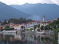
Mergozzo

A street in Mergozzo

Mergozzo Harbor

Mergozzo

Mergozzo lake


literature
- Various authors: Comuni della Provincia del Verbano-Cusio-Ossola. Consiglio Regionale del Piemonte, Chieri 2012, ISBN = 9788896074503.
- Various authors: Il Piemonte paese per paese. Bonechi Editore, Firenze 1996, ISBN = 88-8029-156-4.
- Various authors: Piemonte (non compresa Torino). Touring Club Italiano, Milano 1976, p. 620, Mergozzo online
Web links
- Homepage of the municipality (Italian)
- Mergozzo (Italian) on tuttitalia.it
- Mergozzo (Italian) on comuni-italiani.it
- Mergozzo (Italian) on piemonte.indettaglio.it/ita/comuni
- Public transport timetable of the Verbano-Cusio-Ossola Province (Italian)
- Mergozzo on de.lagomaggiore.net, accessed November 27, 2015
- Mergozzo on the ETHorama platform
Individual evidence
- ↑ Statistiche demografiche ISTAT. Monthly population statistics of the Istituto Nazionale di Statistica , as of December 31 of 2019.
- ↑ Bandiera Arancione. In: Bandierearancioni.it. Retrieved May 9, 2018 (Italian).

Antrona Schieranco | Anzola d'Ossola | Arizzano | Arola | Aurano | Baceno | Bannio Anzino | Baveno | Bee | Belgirate | Beura-Cardezza | Bognanco | Borgomezzavalle | Brovello-Carpugnino | Calasca-Castiglione | Cambiasca | Cannero Riviera | Cannobio | Caprezzo | Casale Corte Cerro | Ceppo Morelli | Cesara | Cossogno | Craveggia | Crevoladossola | Crodo | Domodossola | Druogno | Formazza | Germagno | Ghiffa | Gignese | Gravellona Toce | Gurro | Intragna | Loreglia | Macugnaga | Madonna del Sasso | Malesco | Masera | Massiola | Mergozzo | Miazzina | Montecrestese | Montescheno | Nonio | Oggebbio | Omegna | Ornavasso | Pallanzeno | Piedimulera | Pieve Vergonte | Premeno | Premia | Premosello-Chiovenda | Quarna Sopra | Quarna Sotto | Re | San Bernardino Verbano | Santa Maria Maggiore | Stresa | Toceno | Trarego Viggiona | Trasquera | Trontano | Valle Cannobina | Valstrona | Vanzone con San Carlo | Varzo | Verbania | Vignone | Villadossola | Villette | Vogogna