
Hopschusee
| Hopschusee | ||
|---|---|---|

|
||
| The Hopschusee. In the background the Monte Leone and the Hübschhorn (right). | ||
| Geographical location | Simplon Pass | |
| Drain | Taferna → Saltina → Rhone → Mediterranean | |
| Data | ||
| Coordinates | 645 079 / 122512 | |
|
||
| Altitude above sea level | 2018 m above sea level M. | |
| surface | 1.3 ha | |
|
particularities |
Mountain lake |
|

The Hopschusee is a mountain lake on the Simplon Pass at 2018 m above sea level. M. The lake is a tourist destination and can be reached from the Simplon Pass on foot in 15 minutes.
The Hopschusee lies directly on the watershed between the Rhone and Po . The lake's water flows over the Hobschugrabe, Taferna, Saltina and Rhone west of Marseille into the Mediterranean. The Chrummbach, only 300 meters away from the Hopschusee, flows over the Doveria , Tosa , Ticino and Po into the Adriatic Sea .
The Ursuline Sisters' holiday home is 400 meters northeast of the lake . 500 meters southeast of the lake is the symbol of the Simplon, the Steinandler Monument , which was erected by the 11 Mountain Brigade as a symbol of vigilance and in memory of the “Watch on the Simplon” during the Second World War . Alp Hopsche is located 140 meters southwest of the Hopschusee . Today the buildings of the Alp are mainly used as summer vacation homes.

Hopschusee and Fletschhorn in summer.
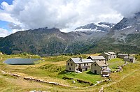
Hopsche Alpine settlement with Hopschusee lake

Hopsche with Hübschhorn

.jpg)

Web links
Individual evidence
- ↑ a b Hopschusee on the map of the Federal Office of Topography : [1]
- ↑ Hobschugrabe and Taferna on the map of the Federal Office of Topography : [2]
- ↑ Chrummbach on the map of the Federal Office for Topography : [3]
- ↑ The Ursuline Sisters' Holiday Home
- ↑ The golden eagle