Mattmark reservoir
| Mattmark reservoir | |||||||
|---|---|---|---|---|---|---|---|
| Mattmarksee and the Allalin Glacier | |||||||
|
|||||||
|
|
|||||||
| Coordinates | 640 363 / 98636 | ||||||
| Data on the structure | |||||||
| Lock type: | Earthfill dam | ||||||
| Construction time: | 1960-1967 | ||||||
| Height of the barrier structure : | 117 | ||||||
| Height above the river bed : | 93 m | ||||||
| Height of the structure crown: | 2204 m above sea level M. | ||||||
| Building volume: | 10 500 000 m³ | ||||||
| Crown length: | 780 m | ||||||
| Power plant output: | Electrical output of the two-stage system: 1st stage: Zermeiggern: 74 MW 2nd stage: Stalden: 180 MW Total output: 254 MW |
||||||
| Operator: | Kraftwerke Mattmark AG | ||||||
| Data on the reservoir | |||||||
| Altitude (at congestion destination ) | 2197 m above sea level M. | ||||||
| Water surface | 1.76 km² | ||||||
| Reservoir length | 3.2 km | ||||||
| Storage space | 100 million m³ | ||||||
| Total storage space : | 101 million m³ | ||||||
| Catchment area | 37.1 km² | ||||||
| Design flood : | 150 m³ / s | ||||||
| Particularities: |
Highest earthfill dam in Switzerland |
||||||
| Detailed map | |||||||
| View from its southern end to the Mattmark Dam | |||||||
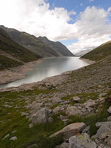
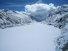
The Mattmark reservoir is a reservoir that is located in the municipality of Saas-Almagell at the southern end of the Saas Valley in the Visp district of the canton of Valais in Switzerland . The lake is used by Kraftwerke Mattmark AG to generate energy.
history
Natural predecessor lake
Before the dam was built, there was a mountain lake in the valley of the young Saas Vispa . Its changing shape and size depended on the advances and retreats of the Allalin Glacier . At the height of the glacier extent around 1600, 1820 and 1850/60, the tongue of the Allalin glacier, which reached down from the western flank, covered the entire width of the valley and thus formed a natural glacial reservoir. When the barrier melted, catastrophic sea eruptions occurred several times. According to chronicles, particularly bad flash floods are said to have destroyed the villages and pastures in the Saas Valley in 1589, 1633, 1680 and 1772. The flood of 1633 forced several families to emigrate. Others worked for years to reclaim the valley floor and vowed not to marry until the work was completed. In the next 14 years, not a single wedding took place in the Saas parish. The eruptions in 1589 and 1633 reached as far as Visp and devastated the cultivated land there. With the eruption of 1680 even 18 houses in Visp were destroyed. In order to prevent such catastrophes, they wanted to build an underground drainage canal around 1900. But the means were lacking.
Artificial reservoir

Isolated studies were carried out early on to use the gradient between Mattmark and the Rhone Valley. The idea was taken up again in 1954 through a study syndicate consisting of, in which Suiselectra , an engineering office from Basel, and Elektrowatt were involved.
On March 25, 1959 took place at the Hotel Beau-Site in Saas-Fee , the establishment of the Kraftwerke Mattmark AG , headquartered in Grund Saas- place. The reservoir is located in the area of the political municipality of Saas-Almagell , the catchment area for the entire hydropower plant extends over the territories of the four Saas municipalities Saas-Almagell, Saas-Balen , Saas-Fee and Saas-Grund. Territorial sovereignty was transferred to the municipality of Saas-Almagell for legal reasons.
Between 1958 and 1959, the six-meter-wide driveway from Saas-Almagell to Mattmark was built, opening up the construction site of the dam. Construction work on the dam began in May 1960 and should last until 1966. Because of the disaster in the summer of 1965, the construction time was extended to 1967. The inauguration of the reservoir took place on June 25, 1969 by Bishop Nestor Adam on the dam. This year, for the first time, the full dam was reached and the dam was put into commercial operation.
In spring 2007 the reservoir was completely emptied for the first time in order to carry out inspections of the systems. However, since the snowmelt, which started earlier than usual, could not be foreseen, the work had to be stopped early, so that in February and March 2008 the lake had to be completely emptied again.
1965 disaster
On August 30, 1965, 88 construction workers, mainly of Italian nationality (56 of 88), were buried under 2,000,000 m³ of ice and rubble when the Allalin glacier collapsed. During the several months of rescue work, none of the people buried could be recovered alive under the layer of rubble that was up to 50 meters thick in places. The risk involved in building the accommodation barracks directly below the glacier tongue that finally broke off was not taken into account. No other reservoir in Switzerland claimed so many victims when it was built.
Mattmark power plants
The catchment area of the Mattmark power plants covers 88 km². These include Kreuzboden, Almageller and Furggbach as well as Allalin and Hohlaub glaciers. The intermediate catchment area with the Saas-Fee, Schweib- and Riedbach region has a size of 74 km².
The total installed turbine output is 260.6 MW ( megawatts ), the average annual production 652.0 million kWh. This also includes information about the Saas Fee power plant, which does not get its water from the Mattmark reservoir.
The individual power plants have the following key figures:
- Zermeiggern power plant (two vertical-axis Francis turbines of 37 MW)
- Zermeiggern pumping station (two vertical axis pumps, 1-flow, 4-stage to 23 MW)
- Stalden power plant (two single-jet, horizontal-axis double Pelton turbines of 92.5 MW)
- Saas Fee power plant (a two-nozzle, horizontal-axis Pelton turbine of 1.55 MW)
literature
- Toni Ricciardi, Sandro Cattacin, Rémi Baudouï: Mattmark, August 30, 1965. The disaster. Seismo, Zurich 2015, ISBN 978-3-03777-161-7 .
- B. Gilg: The Mattmark Power Plant: Project overview . In: Schweizerische Bauzeitung . 1961, doi : 10.5169 / SEALS-65588 .
documentation
- Patricia Wagner, Cristina Karrer: The accident of Mattmark. SRF 1 , DOK , 2015 (50 min)
Web links
- Mattmark reservoir on the ETHorama platform
- Overview of the plants on the website of Kraftwerke Mattmark AG
- SRG archive: Report on the glacier accident on the Mattmark construction site
- Philippe Reichen: Mattmark, the unresolved tragedy. In: Tages-Anzeiger . August 27, 2015.
Individual evidence
- ↑ Geoserver of the Swiss Federal Administration ( information )
- ^ Rico Senti, Marcel Lutz: Mattmark . Ed .: Swiss Dam Committee. ( swissdams.ch [PDF]).
- ↑ a b c Lakes in Switzerland: Natural and storage lakes, Federal Office for the Environment FOEN, 2007 ( Memento from October 5, 2008 in the Internet Archive ) → Lakes in Switzerland (PDF, archive version)
- ↑ a b Federal Office of Energy SFOE: Statistics on hydropower plants. Retrieved June 14, 2020 .
- ^ Walter Ruppen: Visp VS. Settlement and buildings . (= Swiss Art Guide. 1953; No. 356: Ser. 36). 1981, ISBN 3-85782-356-9 .
- ↑ B. Gilg: The Mattmark power plant. Swiss construction newspaper
- ^ Kraftwerke Mattmark AG. In: Commercial Register of the Canton of Valais. Retrieved June 14, 2020 .
- ^ Paul Martone: Saastal. In: Historical Lexicon of Switzerland .
- ^ Peter Josef Ruppen, Gustav Imseng, Werner Imseng: Saaser Chronik 1200-1988 . Ed .: Saas-Fee tourist office. S. 123 f., 163 .
- ^ History. In: Saas Almagell Online. Retrieved June 14, 2020 .
- ↑ Sonia Fenazzi: Symbol for the dark side of Swiss history. In: swissinfo.ch. SRG, August 28, 2015, accessed on June 14, 2020 .
- ^ The company Kraftwerke Mattmark AG. KWM, accessed on June 14, 2020 .
- ↑ Mattmark: Dark Side of Building History. on: swissinfo.ch
- ↑ Death in Mattmark. In: NZZ . August 31, 2015.
- ↑ 88 Dead - The Shame of Mattmark. In: Tages-Anzeiger . August 26, 2015.
- ↑ Construction work on the Mattmark Dam In: Swiss film week show . August 26, 1965.
- ↑ Mattmark, the unresolved tragedy In: Tages-Anzeiger. August 28, 2015.
- ↑ Energy generation in the Saas Valley. KWM, accessed on June 14, 2020 .


