Trough valley
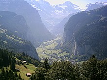
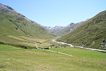
A trough valley or U-valley is a large valley shape with strong relief mountains overformed by glaciers . It is characterized by a typical U-shaped cross profile in the lower area.
Form treasure

The lower, U-shaped profiled valley area of a trough valley was excavated by glacier currents and the rock fragments they carried with them and sometimes completely filled. Depending on the distance to the mountain ridge, this has happened more or less often in the course of the current Ice Age . In high mountains such as the Alps , this valley area, with its sometimes extremely steep slopes and wide valley floor, is sunk into a mostly much less steep valley with a V-shaped cross-section. This creates a characteristic kink on the valley flank at the upper edge of the U-shaped part. It is called the edge of the trough or the edge of the trough and the flattening that is often present above is called the trough shoulder . Since its surface, unlike the rugged slope above it, can be smoothed, the trough shoulder is also known as the ground joint . Its upper edge can also be very pronounced and is then referred to as the cut flute .
It is typical of the longitudinal profile that the slope of the valley floor is unbalanced and the valley range can even be divided by bars between which troughs filled with lakes or flat valley floors formed by loose sediments can extend .
In the high mountains, glacial valleys often begin with trough-shaped high valleys, which on the mountain side can be framed by cirque walls . The steep-walled trough valley often begins below it with a clear gradient ; this can be very distinctive if several high valleys meet there ( confluence level ). Side valleys of trough valleys can either be high-lying, former firn hollows , or they can also be trough-shaped and usually flow out as hanging valleys .
Emergence
Most of the trough valleys merely represent over-shaping of previously fluvial valleys. Their surface formation results from the interrelation of the differently acting erosion forces in the course of an ice flow and the respective resistance of the rock bedrock. Since a glacier does not primarily transport the transported rock material at the bottom like a mountain stream and deposit it again and again, but rather carries it with it distributed over the entire body of ice, mostly to the end, an ice flow does not tend to develop a balanced longitudinal profile. Longitudinal steps, for example triggered by more resistant rocks crossing, cause increased deep erosion at the step base, which often leads to deep valley basins at these points.
The erosion force of a glacier is particularly strong where the pressure conditions in the increasingly solidified firn snow ultimately lead to alternating thawing and re-freezing ( regulation ) at the ice base and thus to particularly effective erosion processes such as detraction . But the meltwater flowing under pressure at the glacier base also develops a strong erosion force. From this area onwards, increased deep erosion of the glacier flow often sets in, as evidenced by the sometimes abrupt end of the trough valley after the glacier has thawed. The sometimes slightly overhanging trough walls show that side erosion on all sides is also effective.
A second focus of erosion is the edge of the glacier. At the beginning of the glacier, very steep back walls of the cirque can be free of ice and then become steeper at the upper limit of the firn due to increased frost weathering at the so-called black-and-white border . On the trough shoulders, the smoothing goes back partly to the abrasion of earlier, higher glacier levels - the cut throat is then also formed there by the increased alternation of frost at the boundary between glacier and rock - and partly to erosion forms of meltwater channels that can accompany an ice flow - the cut throat is then more the result of side erosion of such flank channels. In mid-mountain-like relief forms a trough shoulder is less common in appearance, especially since they often turns into surrounding undulating, partly formed by former Plateauvergletscherung plateaus.
After the valley glacier has melted, only the trough valleys in particularly stable rocks retain their shape; Normally, on the slopes and valley walls, deprived of their abutment from glacier ice, landslides of different sizes and speeds set in. They range from gradual subsidence and landslides , which increasingly narrow the wide valley floor , to landslides that can completely cover it. The lateral moraines deposited on the valley slopes also become unstable and form scree slopes that further blur the valley's original trough shape. The valley steps are first overcome by the streams in waterfalls , but then often cut up like a gorge (example: Aare Gorge ). The lake basins behind it can also fall dry in this way, not only because the confluences of tributaries are filled with gravel .
Similar shapes
Occasionally, high valley races such as the Inntalter races or Kames are confused with trough shoulders. The upper edges of fluvial erosion valleys, which were later cut into the valley floors of stepped trough valleys, do not represent trough shoulders. If such notch valleys are later partially filled with sediments, they are also not to be referred to as trough valleys, but rather as box valleys .
Cultural landscape significance
Typically pronounced trough valleys are, despite their width and poor slopes in places, only of limited settlement and transport advantages. The valley floor is filled with river gravel and is often swampy. The meandering rivers overflow their banks. Today the swamps are mostly drained and the rivers straightened. Above all, however, the lowest valley locations are at risk of frost from cold air lakes . Higher elevations that are not too steep and suitable for settlement and agriculture are mostly the alluvial and scree fans of flowing streams. In some deep-lying trough valleys such as the Lauterbrunnen valley , the trough shoulders have proven to be the more suitable settlement areas.
Deep alpine trough valleys have become more important in connection with the construction of railways and trunk roads . They result in very close, low-lying base points for tunnel construction through the main ridges of the mountain range. Previously, the valley steps and the bars cut by narrow gorges in the course of many trough valleys represented more serious traffic obstacles than some mountain passes that were lowered by glacier transfluences . Well-known examples are the Viamala or the Schöllenen .
However, the less steep and typical trough valleys, which are largely filled with gravel, are of great importance for alpine settlement. Together with the inner alpine longitudinal valleys , they represent a network of colonizable valley areas with favorable climatic conditions.
Spread of trough valleys
Trough valleys are typical worldwide for mountains with recent or earlier glaciation. The degree of preservation of its typical treasure trove of forms depends on the age of the last glacial overprint and the intensity of the erosion since then (fluvial fragmentation, frost debris formation).
Examples of trough valleys are, in addition to the fjord coasts of North and South America, Norway and New Zealand, the Yosemite Valley in California, the Ordesa Valley in the Pyrenees or the Lauterbrunnen Valley in the Alps.
Examples of other trough valleys in the Alps:
- Engadine
- upper Ennstal between Radstadt and Admont
- upper Murtal between Sankt Michael im Lungau and Bruck an der Mur
- Main valleys of the Glarnerland ( Canton Glarus )
- Königssee valley
- Münstertal as an example of a trough valley almost buried by masses of sagging and debris
- Stubai Valley
literature
- Frank Ahnert: Introduction to Geomorphology. 3rd edition, 477 pages, Verlag Eugen Ulmer, Stuttgart 2003 ISBN 3-8001-2813-6
- Herbert Louis and Klaus Fischer: General Geomorphology. 4th renewed and expanded edition, Walter de Gruyter Verlag, Berlin and New York 1979 ISBN 3-11-007103-7


