Dolina Roztoki
| Dolina Roztoki | ||
|---|---|---|
|
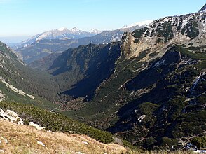
Dolina Roztoki from the Krzyżne mountain pass |
||
| location | Lesser Poland Voivodeship , Poland | |
| Waters | Roztoka | |
| Mountains | High Tatras , Tatras , Carpathians | |
| Geographical location | 49 ° 13 '31 " N , 20 ° 4' 21" E | |
|
|
||
| height | 1020 to 1570 m npm | |
| length | 5 km | |
| climate | High mountain climate | |
The trough valley Roztokatal ( Dolina Roztoki in Polish ), formed by glaciers in the Ice Age, is a side valley of the Bialka valley in the Polish High Tatras in the Lesser Poland Voivodeship . It is below the hanging valleys Fünfseental ( Dolina Pięciu Stawów Polskih ) Roztoka Marmot ( Świstówka Roztocká ) and Buchental ( Dolina Buczynowa ).
geography


The valley is (without the long Hängetal Fünfseental) around 5 km long, with the Fünfseental around 8 km long and surrounded by mountains up to 2300 m high. a. the Walachenkopf massif ( Wołoszyn ) in the north and the Brandkoppe ( Opalony Wierch ) and the Liptauer Grenzberg ( Spiglasowy Wierch ) in the south. It has an area of 7 km² or 14 km² with the hanging valley.
The valley falls from the southwest to the northeast from about 1570 meters to 1020 meters. It is traversed by the Roztoka mountain river, into which the Buczynowy Potok mountain stream and various smaller mountain streams from the couloirs, some of which only have occasional water, flow. In the upper part of the valley there are two waterfalls: Siklawa and Buczynowa Siklawa . In the lower part of the valley is the Wodogrzmoty Mickiewicza waterfall .
In the valley there are three small caves Dziura nad Roztoką , Dziura nad Nową Roztoką and Gowoniowa Nyża .
etymology
The name is derived from the name of the Roztoka river that flows through the valley. Roztoki is the genitive of Roztoka.
Flora and fauna
The area below the tree line is covered with an old coniferous forest. Some of the trees here are up to 400 years old. Mountain pines grow on the slopes. The valley is a retreat for deer, chamois and bears.
climate
There is a high mountain climate in the valley.
Alpine farming
Before the Tatra National Park was established in 1954, the valley was used for alpine farming. After that, the owners of the alpine pastures were expropriated or forced to sell. Former alpine huts are still in the valley.
tourism

- ▬ From the Schronisko PTTK shelter w Dolinie Roztoki , a green hiking trail leads through the valley.
- ▬ In the upper area, a black marked hiking trail branches off to the Schronisko PTTK w Dolinie Pięciu Stawów Polskich .
- ▬ In the upper area, a yellow marked hiking trail leads on the north-west slope to the Krzyżne mountain pass.
literature
- Zofia Radwańska-Paryska, Witold Henryk Paryski, Wielka encyklopedia tatrzańska , Poronin, Wyd. Górskie, 2004, ISBN 83-7104-009-1 .
- Tatry Wysokie słowackie i polskie. Mapa turystyczna 1: 25.000, Warszawa, 2005/06, Polkart ISBN 83-87873-26-8 .


