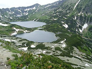
Dolina Pięciu Stawów Polskich
| Dolina Pięciu Stawów Polskich | ||
|---|---|---|
|
Dolina Pięciu Stawów Polskich from the hanging valley Świstówka Roztocka |
||
| location | Lesser Poland Voivodeship , Poland | |
| Waters | Roztoka | |
| Mountains | High Tatras , Tatras , Carpathians | |
| Geographical location | 49 ° 12 '35 " N , 20 ° 2' 13" E | |
|
|
||
| height | 1625 to 1900 m npm | |
| length | 4 km | |
| climate | High mountain climate | |

The hanging valley Dolina Pięciu Stawów Polskich (German Fünfseetal ), formed by glaciers in the Ice Age , is the southwestern extension of the Roztokatals , a trough valley that is in turn a side valley of the Bialkatal in the Polish High Tatras in the Lesser Poland Voivodeship . It lies below the hanging valleys : Kegelkar ( Dolina pod Kołem ) and Ödes Kar ( Dolina Pusta ).
geography
The valley is around 4 km long and surrounded by mountains over 2300 m high. a. the massif of the Seealmspitze ( Świnica ) with its north ridge in the southwest and the Kupferberg ( Miedziane ) in the east and the main ridge of the Tatra Mountains in the south. It has an area of approx. 7 km².
The valley falls from the southwest to the northeast from around 1900 meters to 1626 meters. It is traversed by the tributaries of the Roztoka Mountain River, some of which flow underground and at the end flow into the Great Polish Lake . Many streams only carry water from time to time and collect it from the couloirs on the slopes of the valley. The valley drains through the Siklawa waterfall into the Roztokatal valley . The other lakes in the valley are the front lake ( Przedni Staw ), the small lake ( Mały Staw ), the black lake ( Czarny Staw ), the ox-eye ( Wole Oko ), the rear lake ( Zadni Staw ), and the copper lake ( Szpiglasowe Stawki ).
etymology
The Polish name can be translated as "Valley of the Five Polish Lakes", which is also what the German name refers to. The name is misleading as there are at least seven lakes, four large lakes and numerous smaller ponds in the valley.
Flora and fauna
The valley lies above the tree line and is covered in the lower area by mountain pines, some of which are up to 400 years old. The valley is a refuge for chamois and marmots.
climate
There is a high mountain climate in the valley.
Alpine farming
Before the Tatra National Park was established in 1954, the valley had been used for alpine farming since the 17th century. After that, the owners of the alpine pastures were expropriated or forced to sell. Former alpine huts are still in the valley.
tourism
Numerous hiking trails lead through the valley from the surrounding mountain passes and peaks. At the upper edge of the northern slope, the red marked Orla Perć high trail (Eagle Walk) leads.
- ▬ ▬ A green and a black marked hiking trail lead up from the Roztokatal valley.
- ▬ A yellow marked trail leading from the valley to the mountain pass Kreuzsattel ( Krzyżne ).
- ▬ A blue-marked hiking trail leads from the Meerauge mountain lakeover the Świstówka Roztocka mountain passinto the valley.
- ▬ A blue-marked hiking trail leads from the Polish Green Lake ( Zielony Staw Gąsienicowy ) over the Riegelscharte ( Zawrat ) into the valley.
- ▬ A yellow-marked hiking trail leads from the Meerauge mountain lakeover the Kupfersattel mountain pass( Szpiglasowa Przełęcz ) into the valley.
- ▬ A yellow marked hiking trail leads from the Polish Black Lake ( Czarny Staw Gąsienicowy ) over the Gemsenscharte ( Kozia Przełęcz ).
- ▬ A black hiking trail leads from the valley to the Gemsenberg summit( Kozi Wierch ).
- In the past, a marked hiking trail led from the valley to the Glatten Pass ( Gładka Przełęcz ) and from there to Slovakia .
In the lower area is the highest shelter in Poland Schronisko PTTK w Dolinie Pięciu Stawów Polskich on the mountain lake Przedni Staw Polski .
literature
- Zofia Radwańska-Paryska, Witold Henryk Paryski, Wielka encyklopedia tatrzańska , Poronin, Wyd. Górskie, 2004, ISBN 83-7104-009-1 .
- Tatry Wysokie słowackie i polskie. Mapa turystyczna 1: 25.000, Warszawa, 2005/06, Polkart ISBN 83-87873-26-8 .
map
panorama


