Świnica
| Świnica | ||
|---|---|---|
|
View from the Orla Perć high path |
||
| height | 2301 m npm | |
| location | Poland / Slovakia | |
| Mountains | High Tatras | |
| Coordinates | 49 ° 13 '10 " N , 20 ° 0' 34" E | |
|
|
||
| Type | Rock summit, two-man summit | |
| First ascent | 1867 by Maciej Sieczka | |
The Świnica ( Czech / Slovak Svinica , German: Seenalmspitze) is a mountain on the Polish-Slovak border in the High Tatras with 2301 m. It has two peaks that differ by about 10 meters. The lower one is 2291 m high and, unlike the higher one, is not accessible to hikers. Between them lies the Lower Seealmkerbe mountain pass ( Świnicka Szczerbina Niżnia ) at 2278 m. Sometimes the Seealmkoppe ( Świnicka Kopa ) is also referred to as the third peak of the Świnica . The Świnica is one of the peaks of the western Tatras, near the transition to the West Tatra .
Location and surroundings
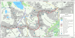
The state border runs over the main ridge of the Tatra Mountains, on which the Świnica is located. Below the summit are three valleys, the Seealmtal ( Dolina Zielona Gąsienicowa ) in the northwest, the Kegelkar ( Dolina pod Kołem ) in the northeast and the Silent Valley ( Dolina Cicha ) in the south. There are numerous climbing routes in its approx. 500 m high northeast face.
From the summit of Mała Walentkowa Czuba in the Walentkowa Grań massif in the east, the Świnica is separated by the Walentkowa Przełęcz mountain pass , from the western summit of the Middle Tower by the Seealmsattel ( Świnicka Przełęcz ) mountain pass and from the northern summit of the Upper Seealm Tower ( Gąsienicowa ) through the Obere Seealmscharte mountain pass ( Gąsienicowa Przełączka ).
etymology
The Polish name Świnica is derived from the shape of the peak, which is reminiscent of a pig's head. Świnia is the Polish word for pig.
The German name Seenalmspitze is derived from the north-west (on the Polish side) of the mountain, the lake-rich valley called Dolina Zielona Gąsienicowa , which in the 19th century was also called Dolina Stawiańska (and its alpine pasture, therefore, Dolina Stawiańska ), in English Seental and Seenalm . However, these names are no longer used. Only one area of the valley is still called Roztoka Stawiańska . The term Schweinkopf was also used in German.
Flora and fauna
Despite its height, Świnica has a colorful flora and fauna. Numerous plant species occur, especially high alpine flowers and grasses. In addition to insects and mollusks and birds of prey, marmots and chamois also visit the summit.
Ascents
First ascents:
- Summer - Maciej Sieczka , Eugeniusz Janota , Bronisław Gustawicz and Stanisław Librowski on July 22, 1867
- Winter - Jerzy Maślanka on December 30, 1907
While climbing the Świnica on the Polish side alone, more than 30 people have died in an accident. The greatest disaster occurred on August 15, 1939, when six hikers were killed in a thunderstorm.
tourism

The Świnica is a very popular with hikers summit. The ascent is moderately difficult and the summit can be reached quickly and easily along the main Tatra ridge from the neighboring Kasprowy Wierch , to which a cable car leads from the Zakopan district of Kuźnice . The last part of the way is chain-secured. The summit is also very popular with climbers, especially the approximately 350 meter high northeast face.
Routes to the summit
The hiking trail on the Swinica leads along the main ridge of the Tatras and the Polish-Slovak border.
- ▬ A red marked hiking trail leads from Kasprowy Wierch over the summits Beskid and Skrajna Turnia as well as the mountain passes Liliowe and Świnicka Przełęcz to the summit and on to the Orla Perć high trail. From the side of the Zawrat mountain passand thus the Dolina Pięciu Stawów Polskich and Dolina Gąsienicowa valleys, the ascent is also possible on the same hiking trail from the opposite direction. The Schronisko PTTK Murowaniec and Schronisko PTTK w Dolinie Pięciu Stawów Polskich mountain huts are suitable starting points for an ascent from the valleys.
Web links
supporting documents
- Zofia Radwańska-Paryska, Witold Henryk Paryski, Wielka encyklopedia tatrzańska, Poronin, Wyd. Górskie, 2004, ISBN 83-7104-009-1 .
- Tatry Wysokie słowackie i polskie. Mapa turystyczna 1: 25.000, Warszawa, 2005/06, Polkart, ISBN 83-87873-26-8 .


