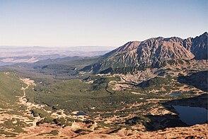
Roztoka Stawiańska
| Roztoka Stawiańska | ||
|---|---|---|
|
View from the Liliowe mountain pass |
||
| location | Lesser Poland Voivodeship , Poland | |
| Mountains | High Tatras , West Tatras , Tatra , Carpathians | |
| Geographical location | 49 ° 14 '12 " N , 19 ° 59' 47" E | |
|
|
||
| height | 1510 to 1660 m npm | |
| climate | High mountain climate | |

The glacial formed by glacial plateau Roztoka Stawiańska located in Seealmtal ( Dolina Gąsienicowa ), specifically in the valley Dolina Zielona Gąsienicowa below the Hängetals Dolina Sucha Stawiańska in the Polish Tatras and West Tatra in the Lesser Poland .
geography
The plateau is surrounded by mountains over 2000 meters high, in particular the Kasprowy Wierch massif . The border between the High Tatras in the east and the Western Tatras in the west runs through the plateau.
There are numerous smaller lakes on the plateau:
- Einzelsee ( Jedyniak )
- Lonely lake ( Samotniak ),
- Lower and Upper Twin Lakes ( Dwoiśniak ),
- Drilling Lake ( Troiśniak ),
- Polish angelica lake ( Litworowy Staw Gąsienicowy ),
- Twin Lake ( Dwoisty Staw Gąsienicowy ),
- Mokra Jama .
The water from the numerous small streams seeps away on the plateau. Little of this arrives in the Seealmer Trockenbach mountain stream . Most of the water flows underground in the valley Dolina Goryczkowa in the Western Tatras , where the karst spring Goryczkowe Wywierzysko its way back to.
etymology
The name is derived from the fact that there are numerous lakes in this section of the Dolina Gąsienicowa valley. It can be translated as a lake plain .
Flora and fauna
The plateau lies above the tree line. It is overgrown with mountain pines.
climate
There is a high mountain climate on the plateau.
Alpine farming
The plateau has been used for alpine farming since the 17th century. It belonged to the Hala Gąsienicowa mountain pasture . After the establishment of the Tatra National Park in 1954, the former owners were expropriated or forced to sell. Since the alpine farming is no longer in operation, the valley has grown over with mountain pines.
tourism
- ▬ There is a yellow-marked hiking trail on the plateau from the Schronisko PTTK Murowaniec refuge to the top of Kasprowy Wierch .
- ▬ A black marked hiking trail leads from the plateau to the Świnicka Przełęcz mountain pass.
- ▬ A green marked hiking trail leads from the plateau to the Liliowe mountain pass.
- ▬ A blue-marked hiking trail leads from the Schronisko PTTK Murowaniec mountain hutto the Czarny Staw Gąsienicowy mountain lake.
On the plateau, the approximately 8.5 km long Gąsienicowa ski slope leads from Kasprowy Wierch down to the Zakopan district of Kuźnice, as well as a chairlift from the bottom of the valley to Kasprowy Wierch, the Hala Gąsienicowa chairlift .
literature
- Zofia Radwańska-Paryska, Witold Henryk Paryski: Wielka encyklopedia tatrzańska . Poronin, Wyd. Górskie, 2004, ISBN 83-7104-009-1 .
- Tatry Wysokie słowackie i polskie. Mapa turystyczna 1: 25.000, Warszawa, 2005/06, Polkart, ISBN 83-87873-26-8 .


