
Sucha Woda Gąsienicowa
| Sucha Woda Gąsienicowa | ||
 Zielony Staw Gąsienicowy , source of the river |
||
| Data | ||
| location | Poland | |
| River system | Vistula | |
| Drain over | Sucha Woda → Biały Dunajec → Dunajec → Vistula → Baltic Sea | |
| source |
Czarny Staw Gąsienicowy 49 ° 14 ′ 0 ″ N , 20 ° 1 ′ 4 ″ E |
|
| Source height | 1672 m npm | |
| confluence | with the Filipczański Potok to Sucha Woda east of the village Lichajówki coordinates: 49 ° 18 '41 " N , 20 ° 3' 59" O 49 ° 18 '41 " N , 20 ° 3' 59" O |
|
| Mouth height | 830 m npm | |
| Height difference | 842 m | |
| Bottom slope | 65 ‰ | |
| length | 13 km | |
| Right tributaries | Czarny Potok Gąsienicowy , Pańszczycki Potok | |
| Communities | Zakopane | |
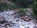
The Seealmbach ( Polish Sucha Woda Gąsienicowa ) is a mountain river about thirteen kilometers long in the valleys Seealm and Dolina Suchej Wody Gąsienicowej in the Lesser Poland Voivodeship in Poland . It has the character of a high mountain river.
geography
The river has its source in the Polish Green Lake , flows through the valley Seealm and Dolina Suchej Wody Gąsienicowej and merges with the mountain river Filipczański Potok to form Seealmbach ( Sucha Woda ) in the High Tatras . Almost the entire course of the river is in the Tatra National Park , it forms the border between the High Tatras and the Western Tatras .
Surname
The Polish name means "dry water stream". The term "Trockenbach" is also found in German.
Flora and fauna
The water of the Seealmbach is clean, rainbow trout, trout, grayling, bullhead and minnow live in the river. The river initially flows above the tree line and is later surrounded by dense spruce forests.
tourism
The river is accessible via numerous hiking trails.
River course

Upper course

Upper course
Lower course

Lower course


literature
- Zofia Radwańska-Paryska, Witold Henryk Paryski: Wielka encyklopedia tatrzańska. Wydawnictwo Górskie, Poronin 2004, ISBN 83-7104-009-1 .
- Tatry Wysokie słowackie i polskie. Mapa turystyczna 1: 25,000, Polkart, Warszawa 2005/06, ISBN 83-87873-26-8 .