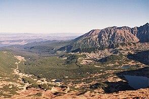
Dolina Suchej Wody Gąsienicowej
| Dolina Suchej Wody Gąsienicowej | ||
|---|---|---|
|
Dolina Suchej Wody Gąsienicowej |
||
| location | Lesser Poland Voivodeship , Poland | |
| Waters | Sucha Woda Gąsienicowa | |
| Mountains | High Tatras , Western Tatras , Carpathian Mountains | |
| Geographical location | 49 ° 15 '54 " N , 20 ° 1' 53" E | |
|
|
||
| height | 1000 to 2301 m npm | |
| length | 8 kilometers | |
| climate | High mountain climate | |
The glacial glacial shaped valley of Seealmer dry Bach ( Polish Dolina Suchej Wody gąsienicowej also Dolina Suchej Wody called), is 8 km long and 21 square kilometers large valley which the boundary between the Tatras and West Tatra in the Polish Lesser Poland in the Municipalities of Zakopane and Poronin . It is located north of the High Tatras main ridge. It has two large side valleys in the High Tatras: Pańszczycatal and Seealm ( Dolina Gąsienicowa ). The latter in turn has two side valleys, the Dolina Czarna Gąsienicowa and the Dolina Zielona Gąsienicowa .
geography
The valley reaches up to the mountain Seealmspitze ( Świnica ) with 2301 m. The valley and its side valleys descend from south to north. Form its slopes
- from the northwest: Kasprowy Wierch and Królowy Grzbiet ,
- from the south: main ridge of the Tatra Mountains to the Seealmspitze further to the Breitkogel ( Koszysta ),
- from the east: the ridge of Ostry Wierch Waksmundzki .
It is traversed by the Seealmer Trockenbach ( Sucha Woda Gąsienicowa ). Its right tributaries in the valley are Seealmer Schwarzbach ( Czarny Potok Gąsienicowy ) and the Pańszczycka brook . Water flows partly underground in cave systems from the valley to other valleys of the Tatras, e.g. B. through the karst springs Goryczkowe Wywierzysko and Wywierzysko Olczyskie and the cave system Jaskinia Kasprowa Niżnia .
In the valley there are some mountain lakes of the High Tatras, u. a. the Karseen Polish Black Lake ( Czarny Staw Gąsienicowy ) and Polish Green Lake ( Zielony Staw Gąsienicowy ) in the upper area and the moraine lakes Lower Forest Lake ( Toporowy Staw Niżni ) and Upper Forest Lake ( Toporowy Staw Wyżni ) in the lower area.
In the last Ice Age, one of the largest glaciers in the Tatra Mountains was located in the valley, with a length of 8 km, an area of 20 km² and an ice thickness of approx. 300 m.
In the valley there are raised bogs with a depth of up to 6 meters. There are also numerous karst phenomena, such as B. karst springs and caves.
etymology
The Polish name is derived from the mountain river Sucha Woda Gąsienicowa , which flows through it, and can be translated as "Valley of the dry water of the Gąsienicowa". Gąsienic was an important family in Zakopane who owned the valley until the National Park was established. Sometimes you can also find the name “Suchawodatal”.
Flora and fauna
The valley lies below and above the tree line. All alpine levels can be found in the valley. The valley is a retreat for deer, bears, wolves, lynxes, chamois, marmots and eagles.
climate
There is a high mountain climate in the valley.
Alpine farming
Before the Tatra National Park was established in 1954, the valley had been used for alpine farming since the 17th century. After that, the owners of the alpine pastures were expropriated or forced to sell. Former alpine huts are still in the valley.
tourism
The valley is very well developed for tourists from Zakopane . In the lower area of the valley there are parking spaces at Oswald-Balzer-Weg , which crosses the valley. There is a refuge in the valley:
There are also some other buildings in the valley:
- an alpine mountain hut "Betlejemka",
- a forest hut "Księżówka" of the National Park Administration,
- a mountain guard hut "Gawra" of the national park administration,
- a weather station of the Polish Academy of Sciences - PAN .
By 2009, a camping site was located in the valley Rąbaniska of PZA , which was later moved.
Numerous hiking trails lead through the valley:
- ▬ A black marked trail leads from Zakopane district Brzeziny to the refuge Schronisko PTTK Murowaniec . Numerous other hiking trails start there. This trail can also be used by cyclists as one of the few in the High Tatras.
- ▬ A red marked trail on the Polish side leads from Zakopane district Toporowa Cyrhla to the peak Rysy . Numerous other hiking trails start there.
literature
- Zofia Radwańska-Paryska, Witold Henryk Paryski, Wielka encyklopedia tatrzańska , Poronin, Wyd. Górskie, 2004, ISBN 83-7104-009-1 .
- Tatry Wysokie słowackie i polskie. Mapa turystyczna 1: 25.000, Warszawa, 2005/06, Polkart ISBN 83-87873-26-8 .


