Dolina Zielona Gąsienicowa
| Dolina Zielona Gąsienicowa | ||
|---|---|---|
|
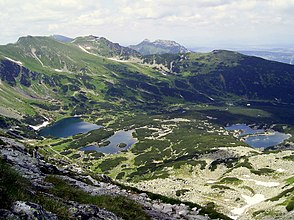
View from the top Kościelec into the valley in the background Kasprowy Wierch and Giewont in the Western Tatras |
||
| location | Lesser Poland Voivodeship , Poland | |
| Waters | Sucha Woda Gąsienicowa | |
| Mountains | High Tatras , Tatras , Carpathians | |
| Geographical location | 49 ° 13 '46 " N , 20 ° 0' 3" E | |
|
|
||
| height | 1400 to 2301 m npm | |
| length | 2 km | |
| climate | High mountain climate | |

The Dolina Zielona Gąsienicowa , formed by glaciers in the Ice Age, is a side valley of the Seealmer Trockenbach valley ( Dolina Suchej Wody Gąsienicowej ), specifically its upper course as the Seealmtal ( Dolina Gąsienicowa ), in the Polish High Tatras in the Lesser Poland Voivodeship .
geography
The valley is around 2 km long and surrounded by mountains over 2300 m high. a. Seealmspitze ( Świnica ), Kasprowy Wierch , Lower Seealm Tower ( Zawratowa Turnia ), Small Polish Chapel ( Mały Kościelec ), Polish Chapel ( Kościelec ) and Uhrocie Kasprowe .
The valley falls from east to west from approx. 2300 meters to 1500 meters. The Sucha Woda Gąsienicowa mountain stream flows through it. The creek flows partly underground. In the upper area are the hanging valleys Świnicka Kotlinka , Dolina Sucha Stawiańska and Irrkessel ( Mylna Kotlinka ) as well as the Karkessel Zadnie Koło and Kocioł Kasprowy .
19 of the 21 mountain lakes of the Seealm are located in the valley. The larger ones include: Polish Green Lake ( Zielony Staw Gąsienicowy , 3.764 ha), Polish Long Lake ( Długi Staw Gąsienicowy , 1.564 ha), Kurtkowiec (1.536 ha z wyspą), Dwoisty Staw Gąsienicowy (1.355 i 0.880 ha), Polish Rear Lake ( Zadni Staw Gąsienicowy , 0.515 ha), Polish angelica lake ( Litworowy Staw Gąsienicowy , 0.407 ha) and Czerwone Stawki Gąsienicowe (0.196 and 0.138 ha); and the smaller ones: Twin Lakes ( Dwoiśniaczek ), Single Lakes ( Jedyniak ), Kesselseelein ( Kotlinowy Stawek ), Lonely Lake ( Samotniak ), the Triplet Lakes ( Troiśniak ) and Mokra Jama .
etymology
The Polish name refers to the Gąsienic family, an important family from Zakopane in the Podhale region at the foot of the High Tatras, who owned the valley, especially the Hala Gąsienicowa (German: Seealm).
Flora and fauna
The valley lies below and above the tree line. It is a retreat for deer, bears, lynx, wolves and golden eagles.
climate
There is a high mountain climate in the valley.
Alpine farming
Before the Tatra National Park was established in 1954, the valley had been used for alpine farming since the 17th century. After that, the owners of the alpine pastures were expropriated or forced to sell.
tourism
There are numerous hiking trails in the valley.
- ▬ A yellow marked hiking trail leads from the Schronisko PTTK Murowaniec refugethrough the valley to the top of Kasprowy Wierch .
- ▬ A black marked hiking trail leads from the Roztoka Stawiańska valleyto the Świnicka Przełęcz mountain pass.
- ▬ A green hiking trail leads from the Roztoka Stawiańska valleyto the Liliowe mountain pass.
- ▬ A blue marked hiking trail connects the * ▬ black marked hiking trail with the Karb mountain pass.
The mountain hut Schronisko PTTK Murowaniec is located on the Hala Gąsienicowa mountain pasture , which is located at the point where the valley meets the Dolina Gąsienicowa valley .
literature
- Zofia Radwańska-Paryska, Witold Henryk Paryski, Wielka encyklopedia tatrzańska , Poronin, Wyd. Górskie, 2004, ISBN 83-7104-009-1 .
- Tatry Wysokie słowackie i polskie. Mapa turystyczna 1: 25.000, Warszawa, 2005/06, Polkart ISBN 83-87873-26-8 .
Web links
panorama


