Liliowe
| Liliowe | |||
|---|---|---|---|
|
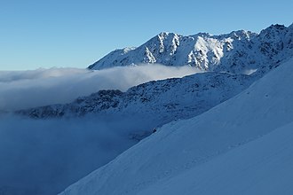
View from the pass into the Dolina Gąsienicowa valley in winter |
|||
| Compass direction | North | south | |
| Pass height | 1953 m npm | ||
| Podhale , Powiat Tatrzański , Lesser Poland , Poland | Slovakia | ||
| Valley locations | Zakopane | Poprad | |
| Mountains | High Tatras , Tatras , Carpathians | ||
| map | |||
|
|
|||
| Coordinates | 49 ° 13 '30 " N , 19 ° 59' 33" E | ||
The Liliowe (German Liliensattel ) is a mountain pass in the south of the Polish Voivodeship Lesser Poland and Slovakia in the High Tatras . The pass is located in the municipality of Zakopane on the main ridge of the Tatra Mountains and connects the Seealm Valley ( Dolina Gąsienicowa ) with the Silent Valley ( Dolina Cicha ). The pass is 1952 m above sea level and high adjacent to the summit Beskid in the West Tatra and edge tower ( skrajna Turnia ) in the Osttatra , specificallyHigh Tatras . This makes the pass the border between the West and High Tatras in the main Tatra ridge.
tourism
▬ A red marked hiking trail leads over the pass along the main ridge of the Tatras from the Dolina Kościeliska valleyto the Orla Perć high-altitude trail(Eagle Walk).
▬ A green marked hiking trail leads to the pass from the Schronisko PTTK Murowaniec mountain hutin the Dolina Gąsienicowa valley.
First ascent
The pass was visited by shepherds in the early modern times. The first to climb is unknown.
literature
- Zofia Radwańska-Paryska, Witold Henryk Paryski, Wielka encyklopedia tatrzańska , Poronin, Wyd. Górskie, 2004, ISBN 83-7104-009-1 .
- Tatry Wysokie słowackie i polskie. Mapa turystyczna 1: 25.000, Warszawa, 2005/06, Polkart ISBN 83-87873-26-8 .

