Beskid (Western Tatras)
| Beskid | ||
|---|---|---|
|
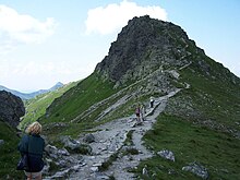
From the Hala Gąsienicowa mountain pasture |
||
| height | 2012 m npm | |
| location | Poland / Slovakia | |
| Mountains | Western Tatras , Carpathian Mountains | |
| Coordinates | 49 ° 13 '42 " N , 19 ° 59' 17" E | |
|
|
||
| Type | Rock peaks | |
| First ascent | 1805 by Stanisław Staszic | |

The Beskid ( Czech / Slovak Beskyd ) is a mountain on the Polish-Slovak border in the Western Tatras at 2012 meters on the main ridge of the Tatra Mountains. It is the easternmost peak of the Western Tatras in Poland.
Location and surroundings
The state border runs over the main ridge of the Tatras , on which the Beskid is located. Below the summit are two valleys, the Dolina Gąsienicowa valley , specifically its hanging valley Dolina Zielona Gąsienicowa in the north and the Dolina Ciemnosmreczyńska valley in the south.
From the summit of Skrajna Turnia in the east, which is already in the High Tatras , the Beskid is separated by the Liliowe mountain pass , and from the western Kasprowy Wierch summit by the Sucha Przełęcz mountain pass .
etymology
The Polish name Beskid is the singular form of Beskidy . Beskidy can be translated as Beskydy .
tourism
The Beskid is popular with hikers. It is on the main route from the upper cable car station to the Kasprowy Wierch.
Routes to the summit
The hiking trail to the Beskid runs along the main Tatra ridge and the Polish-Slovakian border.
- ▬ A red marked hiking trail leads from Kasprowy Wierch over the peaks Skrajna Turnia and Pośrednia Turnia as well as the mountain passes Liliowe and Świnicka Przełęcz to the peak and on to the Orla Perć high-altitude path. From the side of the Zawrat mountain passand thus the Dolina Pięciu Stawów Polskich and Dolina Gąsienicowa valleys, the ascent is also possible on the same hiking trail from the opposite direction. The Schronisko PTTK Murowaniec and Schronisko PTTK w Dolinie Pięciu Stawów Polskich mountain huts are suitable starting points for an ascent from the valleys.
Web links
supporting documents
- Zofia Radwańska-Paryska, Witold Henryk Paryski: Wielka encyklopedia tatrzańska. Wyd. Górskie, Poronin 2004, ISBN 83-7104-009-1 .
- Tatry Wysokie słowackie i polskie. Mapa turystyczna 1: 25,000, Polkart, Warszawa 2005/06, ISBN 83-87873-26-8 .


