Dolina pod Kołem
| Dolina pod Kołem | ||
|---|---|---|
|
Dolina pod Kołem |
||
| location | Lesser Poland Voivodeship , Poland | |
| Mountains | High Tatras , Tatras , Carpathians | |
| Geographical location | 49 ° 12 '53 " N , 20 ° 0' 48" E | |
|
|
||
| height | 2000 to 1900 m npm | |
| length | 1 km | |
| climate | High mountain climate | |
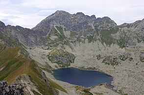
The hanging valley Kegelkar ( Polish Dolina pod Kołem , also Dolinka pod Kołem ), formed by glaciers in the Ice Age , is located southwest of the mountain valley Fünfseental , which in turn represents a hanging valley of the Roztokatal , which is a side valley of the Bialkatal , in the Polish High Tatras in the Lesser Poland Voivodeship . It lies below the main ridge of the Tatra Mountains and the peaks Valentinsberg ( Walentkowy Wierch ), Seealmspitze ( Świnica ), Unterer Seealmturm ( Zawratowa Turnia ), Kleiner Gemsenberg ( Mały Kozi Wierch ) and Kegel ( Kołowa Czuba ) and about 100 m above the Five Lakes Valley .
geography
The valley is almost a km long and surrounded by mountains over 2300 m high, in particular the Seealmspitzen massif . In the valley there are two cirque lakes Rear Polish lake ( Zadni Staw Polski ) and ox-eye ( Wole Oko ) and smaller ponds. Both lakes are connected by a mountain stream. Most of its water flows underground into the Five Lakes Valley and from there into the Polish Black Sea .
etymology
The name is derived from the round rock bank below the Świnica . A German translation of the Polish name could be: valley below the wheel .
Flora and fauna
The valley lies above the tree line. It is a retreat for chamois, marmots and eagles.
climate
There is a high mountain climate in the valley.
tourism
▬ A blue-marked hiking trail leads through the valley from the Fünfseental to the Polish Green Lake over the Riegelscharte ( Zawrat )mountain pass.
▬ Above the valley on the southern ridge of the Świnica , the Orla Perć high-altitude path runs, which can be reached from the valley via the Riegelscharte ( Zawrat )mountain pass.
literature
- Zofia Radwańska-Paryska, Witold Henryk Paryski, Wielka encyklopedia tatrzańska , Poronin, Wyd. Górskie, 2004, ISBN 83-7104-009-1 .
- Tatry Wysokie słowackie i polskie. Mapa turystyczna 1: 25.000, Warszawa, 2005/06, Polkart ISBN 83-87873-26-8 .


