Furggsattel
| Furggsattel | |||
|---|---|---|---|
|
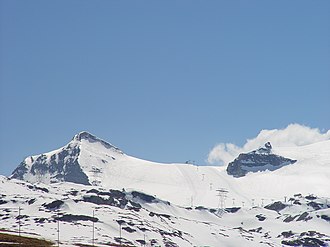
The Furgsattel with the Gandegg tow lift, the Theodulhorn on the left |
|||
| Compass direction | north | south | |
| Pass height | 3349 m above sea level M. | ||
| region | Canton of Valais | Autonomous regions with special status Aosta Valley | |
| Watershed | Matter Vispa | Torrente marbles | |
| Valley locations | Zermatt | Breuil-Cervinia | |
| expansion | Alpine route (alpine transition) | ||
| Mountains | Valais Alps | ||
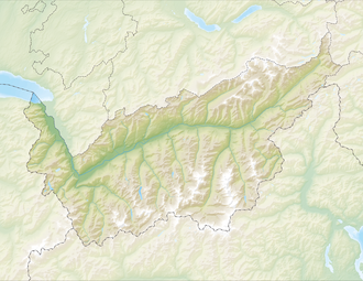
| Map (Valais) | |||
|
|
|||
| Coordinates , ( CH ) | 45 ° 57 '6 " N , 7 ° 42' 10" O ( 620487 / 88925 ) | ||
The Furggsattel is a mountain pass in the Valais Alps . It lies on the border between Switzerland and Italy at 3349 m above sea level. M. height and thus exceeds the nearby Theodulpass by a few dozen meters.
The Furggsattel is embedded between the Furgghorn ( 3451 m ) and the Theodulhorn ( 3469 m ) and connects Zermatt with Breuil-Cervinia .
While the Theodul Pass can only be reached by cable car from Italy , the Furggsattel can be reached from October to June by the glacier chairlift from the Trockener Steg . The glacier lift opened in 2003 and was the first chairlift to be built on a Swiss glacier. It is the longest glacier chairlift in Europe. Special masts, so-called glacier supports , were used for the construction . The mountain station was on Italian soil when it was built, as the saddle point of the glacier was north of it. Due to the glacier retreat, the ridge line and thus the state border has since shifted southwards, so that the mountain station is now on Swiss territory according to a bilateral agreement ("walking border").
Individual evidence
- ↑ Archived version of: Switzerland is getting bigger ( Memento of July 30, 2009 in the Internet Archive ). Daniel Foppa, Tages-Anzeiger , July 27, 2009.
- ↑ Our borders move up : Federal Office of Topography swisstopo, accessed on October 7, 2017

