
Parrot tip
| Parrot tip | ||
|---|---|---|
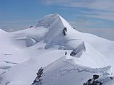
 The Parrotspitze from the south, on the right the Signalkuppe |
||
| height | 4432 m above sea level M. | |
| location | Switzerland / Italy | |
| Mountains | Valais Alps | |
| Dominance | 0.9 km → Signalkuppe | |
| Notch height | 136 m ↓ Seserjoch | |
| Coordinates , ( CH ) | 45 ° 55 '11 " N , 7 ° 52' 17" O ( 633 569 / 85426 ) | |
|
||
| First ascent | August 16, 1863 by Melchior Anderegg , Florence Crauford Grove , William Edward Hall, Reginald Somerled Macdonald, Montagu Woodmass, Peter Perren. | |
| Normal way | Glacier tour over the west ridge | |

The Parrotspitze is a 4432 m above sea level. M. high secondary summit of the Dufourspitze in the Alps .
It is at the Monte Rosa - solid on the border between Italy and Switzerland . Valley locations are Zermatt on the northwest side of the mountain and Alagna in the province of Vercelli on the Italian side.
history
The summit is named after Friedrich Parrot , a German physicist, doctor and alpinist who explored the Monte Rosa massif from 1814 to 1816.
In 1862 came on July 8 , the British Hereford Brooke George and George and Adolphus Warburton Moore together with the mountain guides Christian Almer the Parrotspitze and Matthias Zumtaugwald from Switzerland on the east wall until Abschlussgrat just below the summit before, but returned there around.
The following year, on August 16, the mountain guides Melchior Anderegg and Peter Perren with their customers Reginald S. Macdonald, Florence Crauford Grove , Montagu Woodmass and William Edward Hall managed the actual first ascent of the summit over the west ridge. Your route is now considered the normal route to the summit.
Routes
- The normal route follows the route of the first to climb over the west ridge. The starting point of the glacier tour is the Gnifettihütte ( 3647 m slm ) in Italy, which is reached via the hut Rifugio Città di Mantova . From there on the mostly existing track in 2½ hours to Piodejoch ( 4283 m above sea level ) at Ludwigshöhe . From there in a further 30 minutes in a NE direction to the west ridge and over this (up to 40 ° steep) to the summit. In winter and spring, this route is the most common ski climb.
- On the Swiss side, the west ridge can be reached from the Monte Rosa hut ( 2795 m above sea level ) via the Grenz glacier. However, this route is less common.
- Due to the short distances on the Monte Rosa Stock, the Parrotspitze is often visited as part of crossings. An example of this is the ascent via the normal route and then the descent via the northeast ridge into the Seserjoch ( 4296 m above sea level ) and from there the renewed ascent to the Signalkuppe with the Capanna Regina Margherita . (Can also be done in the opposite direction from the Signalkuppe to the Gnifettihütte.) With little extra effort, it is possible to cross the Balmenhorn , Ludwigshöhe or Schwarzhorn in the ascent from the Gnifettihütte .
gallery
Parrotspitze seen from the Lyskamm.

Normal route on the north side

View of the summit of the Parrotspitze

Panorama in west direction on the summit of the Parrotspitze

Glaciated north side of the Parrotspitze


literature
- Michael Waeber: Valais Alps. Area guide for hikers, mountaineers, ski tourers and climbers. The most popular climbs to all important peaks with descriptions of all recommended ski tours. 13th edition. Bergverlag Rother, Munich 2003, ISBN 3-7633-2416-X .
- Helmut Dumler, Willi P. Burkhardt: Four-thousanders in the Alps. 12th, updated edition. Bergverlag Rother, Munich 2001, ISBN 3-7633-7427-2 .
Web links
- Parrotspitze at 4000m - the four-thousanders of the Alps