Zinalrothorn
| Zinalrothorn | ||
|---|---|---|
|
Summit of the Zinalrothorn |
||
| height | 4221 m above sea level M. | |
| location | Canton of Valais , Switzerland | |
| Mountains | Valais Alps , Weisshorn Group | |
| Dominance | 4.2 km → Weisshorn | |
| Notch height | 490 m ↓ hollow pass | |
| Coordinates | 619.45 thousand / 101497 | |
|
|
||
| First ascent | 22nd August 1864 by the guides Jakob Anderegg and Melchior Anderegg with Florence Crauford Grove and Leslie Stephen | |
| Normal way | Southeast ridge (III (places), otherwise II and I) North ridge (III + (places), otherwise easier) |
|
|
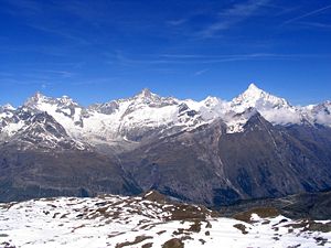
Zinalrothorn (center) between Ober Gabelhorn (left) and Weisshorn (right) of the Weisshorn group , seen from Gornergrat , to the left of Ober Gabelhorn the tip of Dent Blanche is visible |
||
The Zinalrothorn is a 4221 m above sea level. M. high mountain near Zermatt in the Valais Alps . In contrast to many peaks of this height, the Zinalrothorn is a pure rock summit, with three ridges in solid rock.
It takes its name from the holiday resort of Zinal in the Val d'Anniviers , which is located nearby. Until the advent of tourism in the Alps but the mountain was after moming glacier , which has its origin on the northern flank, the name Moming . The Zinalrothorn is only 4 km south of the Weisshorn ( 4505 m above sea level ). From the summit you have an excellent view of the Matterhorn and the Monte Rosa massif .
The first ascent was made by Leslie Stephen and Florence Crauford Grove with the guides Melchior and Jakob Anderegg from Zinal over the north ridge ( ZS, III ) on August 22, 1864 .
The three ridges offer climbs in the medium difficulty range. In addition to the first climber's path over the north ridge, there is also the somewhat less demanding south-east ridge ( ZS, III (places), otherwise II and I ) and the Rothorn ridge ( ZS +, south-west ridge, IV (short point), III + ), one of the most beautiful rock climbs in the area of Zermatt . The starting point for the southeast ridge is the Rothornhütte at an altitude of 3,198 m above sea level. M. , for the north ridge the Mountethütte at 2886 m above sea level. M. The southwest ridge can be reached from the Rothorn or Mountethütte.
literature
- Bernhard R. Banzhaf, Hermann Biner, Vincent Theler: Matterhorn, Dent Blanche, Weisshorn. From Col Collon to the Theodulpass. SAC-Verlag, Bern 2010, ISBN 978-3-85902-297-3 .
- Hermann Biner: Alpine tours in Valais. From Trient to the Nufenen Pass. 3. Edition. SAC-Verlag, Bern 2002, ISBN 3-85902-204-0 .
- Helmut Dumler, Willi P. Burkhardt: Four-thousanders in the Alps. 12th, updated edition. Bergverlag Rother, Munich 2001, ISBN 3-7633-7427-2 .
- Michael Waeber: Valais Alps. Area guide for hikers, mountaineers, ski tourers and climbers. The most popular climbs to all important peaks with descriptions of all recommended ski tours. 12th edition. Bergverlag Rother, Munich 1999, ISBN 3-7633-2416-X .
Web links
- Zinalrothorn on the ETHorama platform
- Zinalrothorn at 4000m - the four-thousanders of the Alps
- The Zinalrothorn
- Zinalrothorn, Summitpost photo
- Zinalrothorn on MountWiki


