Zinal
| Zinal | |
|---|---|
| State : |
|
| Canton : |
|
| District : | Siders (Sierre) |
| Municipal municipality : | Anniviers |
| Postal code : | 3961 |
| former BFS no. : | 6231 |
| Coordinates : | 614466 / 109358 |
| Height : | 1670 m above sea level M. |
| Website: | https://www.valais.ch/de/orte/ |
|
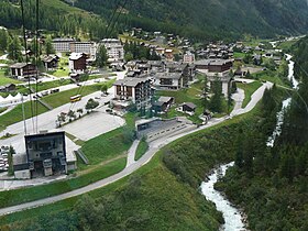
View of Zinal with the valley station of the cable car to Sorebois |
|
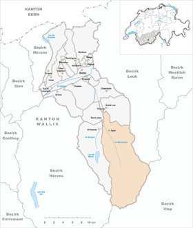
| map | |
Zinal is a holiday resort in the Val d'Anniviers in the French-speaking part of the canton of Valais and belongs to the municipality of Anniviers . The place is known as the starting point for climbing several Valais four-thousand-meter peaks.
geography
Zinal is at the far end of the Val d'Anniviers, a southern side valley of the Rhone Valley in the canton of Valais. The Navisence stream flows through the village and flows into the Rhone at Chippis . The Roc de la vache , the Les Diablons and the Besso , a pre-summit of the Zinalrothorn, rise above the village to the east . To the west of the village rise the Corne de Sorebois and the Garde de Bordon . The plat de la Lé valley floor, used as pasture, extends further up the valley . Behind it, after a rocky step, the valley divides towards Weisshorn with the Weisshorn and Moming glaciers that emanate from it, as well as towards the Zinal glacier , Grand Cornier , Dent Blanche and Ober Gabelhorn . The entire head of the valley with the snow-covered four-thousand-meter peaks is also called the Imperial Crown (Couronne impériale) because of its majestic appearance .
origin of the name
Originally, Zinal was called Chinaz ( cheneau = "gutter"). This alludes to the valley that is narrowing at this point. The first topographers considered this dialect name on a map to be unworthy and changed it to the now known word Zinal.
history
Zinal used to be a Maiensäss village , i.e. a settlement that was not inhabited all year round. The village was inhabited for a few weeks in May and June before the cattle were taken to the alpine pastures, and then again for a few weeks after the cattle were withdrawn in October. In December and January, the hay was finally fed to the cattle for a few weeks.
The first inn was built in 1856. The two-story larch house contained a few small rooms. In 1864 Edward Whymper , the first to climb the Matterhorn , stayed in Zinal. In 1889 a chapel dedicated to St. Bartholomew was built. At the entrance to the choir, the painter Cini created a fresco in 1948 and a Way of the Cross in 1952. Due to the inadequate road connections, the village had to struggle with great economic difficulties and could only develop touristically from 1957, after the road was built.
In the 1960s the cable car to Sorebois was built. Some ski lifts followed. Since then, the place has continuously developed in summer and winter tourism. Until December 31, 2008, Zinal belonged to the municipality of Ayer . Ayer then merged with 5 other valley communities to form the municipality of Anniviers .
population
| Population development | |||||||
|---|---|---|---|---|---|---|---|
| year | 1970 | 1990 | 2008 | ||||
| Residents | 103 | 200 | 250 | ||||
traffic
The road to Zinal was built late in 1957, even by Valaisian standards. The topographical conditions were very demanding. Zinal is connected to the public transport network thanks to the regular postbus courses via Vissoie to Sierre train station . There are also direct courses from Zinal via Grimentz to the Moiry reservoir .
tourism
In 1967 a cable car was built to the 2438 m above sea level. M. located mountain station Sorebois built. The cabins were renewed in 2007. Seen from Sorebois, the Matterhorn rises behind the Imperial Crown (Couronne impériale) . The village has two hotels as well as many holiday apartments and chalets .
summer
300 km of hiking trails are signposted in the mountains around Zinal . The national route no. 6 Alpine Passes Trail from SwitzerlandMobility leads from Turtmanntal over the Meidpass to Zinal and on to the Lac de Moiry and over the Col de Torrent to the Val d'Hérens . With its five mountain huts Cabane du Grand Mountet (SAC) , Cabane Petit Mountet , Cabane d'Arpitettaz (SAC), Cabane de Tracuit (SAC) and Cabane de Sorebois , Zinal is the starting point for the classic routes to the Weisshorn, the Zinalrothorn, the Bishorn and the Ober Gabelhorn of the Weisshorn group . There has been a Foxtrail in Zinal since August 2020 .
winter
The Corne de Sorebois ski area comprises 70 km of slopes. The main slopes are artificially snowed. Since late autumn 2013, a cable car with a gondola capacity of 125 people has been leading from the valley station in Grimentz to the Zinal ski area. Thus, the two ski areas are connected with each other and there is a ski arena with 120 km of slopes, 2 cable cars, 1 gondola , 5 chair lifts and 11 ski lifts. The Grimentz-Zinal ski area has since been one of the 10 largest ski areas in the canton of Valais.
In the valley floor above Zinal called Plat de la Lé , a total of 19 km of cross- country trails are groomed in winter .
gallery
The Val de Zinal with Besso (left)
literature
- Ignace Mariétan: hiking book Val d'Anniviers - Val d'Hérens . Kümmerly + Frey, Bern 1965
Web links
- Official website of Zinal Tourism
- David Rey: Zinal. In: Historical Lexicon of Switzerland .
- Zinal on the ETHorama platform
- Hiking in Switzerland: hiking route no. 6 Alpine passes trail


