Moming Glacier
| Moming Glacier Glacier de Moming |
||
|---|---|---|
|
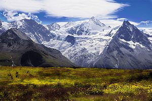
Zinalrothorn and Moming Glacier from the northwest |
||
| location | Canton of Valais , Switzerland | |
| Mountains | Valais Alps , Weisshorn Group | |
| Type | Mountain glacier | |
| length | 3.1 km (2011) | |
| surface | 5.59 km² (2006) | |
| Exposure | Nutrient area north, consumption area northwest | |
| Altitude range | 4070 m above sea level M. - 2580 m above sea level M. (2001) | |
| Tilt | ⌀ 25.3 ° (47%) | |
| Ice volume | 0.35 ± 0.09 km³ (2006) | |
| Coordinates | 618 564 / 102946 | |
|
|
||
| drainage | Navisence , Rhone | |
The Moming Glacier (French Glacier de Moming ) is a slope glacier in the southeast of the Swiss Val de Zinal , in the Valais Alps . Its length was about 3.1 km in 2011, the area was given in 2006 with 6.4 km². Since the 1970s, it has withdrawn about half a kilometer. The glacier extends from 4070 m above sea level. M. at 2580 m above sea level. M. down. Its name goes back to the Latin mons medianus ( middle mountain or middle alp ).
The Moming Glacier takes its starting point on the northern flank of the Zinalrothorn . It flows northwards down a very steep slope and then divides into two tongue lobes, which are separated from each other by a rock wall. The two glacier tongues, each about one kilometer wide, move north-west towards Val de Zinal and are sometimes wildly rugged. Towards the south, the Moming Glacier is separated from the Mountet Glacier, a tributary glacier of the Zinal Glacier , by a ridge ; the south-western end is the pyramid of Besso ( 3668 m above sea level ). Both glacier tongues drain into the Navisence , which flows through the Val d'Anniviers to the Rhone .
location
Location of the Moming Glacier in the Valais Alps (left)
and in the Alps (right in the box).
Web links
- Map section at map.geo.admin.ch
Individual evidence
- ↑ a b Research Institute for Hydraulic Engineering, Hydrology and Glaciology (VAW) of the ETH Zurich (ed.): Mominggletscher. In: Swiss Glacier Measurement Network. ( ethz.ch , also as PDF , accessed on January 31, 2014).
- ↑ a b c Daniel Farinotti, Matthias Huss, Andreas Bauder, Martin Funk: An estimate of the glacier ice volume in the Swiss Alps. In: Global and Planetary Change. 68: 225-231, 2009 ( online ; PDF; 756 kB).
- ↑ a b WGMS: Fluctuations of Glaciers Database. World Glacier Monitoring Service, Zurich 2013 ( DOI: 10.5904 / wgms-fog-2013-11 ), accessed on December 11, 2013
- ↑ Andreas Linsbauer, Frank Paul, Wilfried Haeberli: Modeling glacier thickness distribution and bed topography over entire mountain ranges with GlabTop: Application of a fast and robust approach. In: Journal of Geophysical Research. , Volume 117, F03007, 2012, doi : 10.1029 / 2011JF002313 ( online )


