Ayer (Val d'Anniviers)
| Ayer | ||
|---|---|---|
| State : |
|
|
| Canton : |
|
|
| District : | Sierre | |
| Municipal municipality : | Anniviers | |
| Postal code : | 3961 | |
| former BFS no. : | 6231 | |
| Coordinates : | 612 458 / 114 665 | |
| Height : | 1476 m above sea level M. | |
| Area : | 119.1 km² | |
| Residents: | 700 (December 31, 2007) | |
| Population density : | 6 inhabitants per km² | |
| Website: | www.zinal.ch | |
|
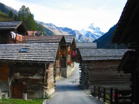
Ayer village street with a view towards Besso |
||
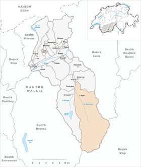
| map | ||
|
|
||
Ayer is a parish of the Deanery of Sierre and a civic community with a civic council of the district of Sierre and was a political municipality in Val d'Anniviers in the canton of Valais in Switzerland until December 31, 2008 .
On January 1st, 2009 Ayer merged with the other five municipalities in the valley ( Chandolin , Grimentz , Saint-Jean , Saint-Luc and Vissoie ) to form the municipality of Anniviers .
The hamlet of Zinal, surrounded by the peaks of Weisshorn , Zinalrothorn , Bishorn , Ober Gabelhorn and Dent Blanche, belongs to Ayer .
history
The municipality is located in the Val d'Anniviers and included the villages of Ayer (1465 m) and Mission, the hamlets of La Comba (1820-24 part of the municipality of Vissoie ), Cuimey, Mottec, Zinal, individual farms, Maiensäss and Alps. First mentioned in 1296 under Ayer. Prehistoric cup stones. Ayer is attested as early as 1327 as a so-called quarter of the Val d'Anniviers. It belonged to the Zenden of Sierre until 1798 and then formed a community with Mission and La Comba. 1811-21 it was united with Vissoie and Grimentz and 1824-1904 it was shared with Grimentz in the possession of Vissoie. Ecclesiastically Ayer belonged to the parish of Vissoie until 1930. Next to the parish church of Sainte-Madeleine in Mission, there are several chapels on the territory of the former parish. Numerous catastrophes such as the flood in 1834 and the village fire in Mission 1838 struck Ayer. Copper , nickel , cobalt and arsenic were mined from 1836 until the early 20th century . Around 1900 the main focus was on growing grain, raising livestock and making cheese. The Vissoie-Ayer road was opened in 1912, the one from Ayer to Zinal in 1951. Between 1950 and 1960, migration was slowed down by the construction of the La Gougra power station in Mottec, the Moiry dam and the development of Zinal as a health resort (hostel in 1856, before 1914 three hotels, 1966–2000 Club Méditerranée, since 1974 mountain run Sierre-Zinal). The 1st sector (1910 92%, 1990 2%) has been replaced by the 3rd sector (numerous commuters) and has almost completely disappeared.
population
| Population development Ayer | ||||||
|---|---|---|---|---|---|---|
| year | 1850 | 1888 | 1900 | 1960 | 2000 | 2007 |
| Residents | 700 | 818 | 789 | 408 | 570 | 700 |
Attractions
literature
- Danielle Allet-Zwissig: Ayer. In: Historical Lexicon of Switzerland . 2017 .
Web links
- Ayer (Val d'Anniviers) on the ETHorama platform
|
|
This version of the article is based on the entry in the Historical Lexicon of Switzerland (HLS), which, according to the HLS's usage instructions, is under the Creative Commons license - Attribution - Distribution under the same conditions 4.0 International (CC BY-SA 4.0). If the article has been revised and expanded to such an extent that it differs significantly from the HLS article, this module will be removed. The original text and a reference to the license can also be found in the version history of the article. |


