Grand Cornier
| Grand Cornier | ||
|---|---|---|
|
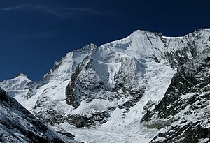
Grand Cornier from the Zinaltal (from the north), behind it on the left half-covered Dent Blanche |
||
| height | 3962 m above sea level M. | |
| location | Canton of Valais , Switzerland | |
| Mountains | Valais Alps | |
| Dominance | 1.72 km → Dent Blanche | |
| Notch height | 431 m ↓ Col de la Dent Blanche | |
| Coordinates | 613 383 / 100079 | |
|
|
||
| First ascent | June 16, 1865 by Edward Whymper , Christian Almer , Michel Croz and Franz Biner | |
| Normal way | Northwest ridge of the Cabane de Moiry ( II ) | |
The Grand Cornier is 3962 m above sea level. M. high mountain in the Valais Alps in the canton of Valais in Switzerland .
The first ascent took place on June 16, 1865 by Edward Whymper , Christian Almer , Michel Croz and Franz Biner .
The normal route leads from the Cabane de Moiry near Grimentz over the crevasse Moiry glacier first south to the pre-summit ( 3843 m ) and at the end over the northwest ridge in a short climb ( III -IV ) to the summit. The pre-summit is usually also the end point of a ski climb.
The Borgne de Ferpècle rises at the foot of the Grand Cornier, on the Ferpècle and Mont Miné glaciers .
location
Location of the Grand Corniers in the Valais Alps (left)
and in the Alps (right).
Web links
- Grand Cornier on the ETHorama platform


