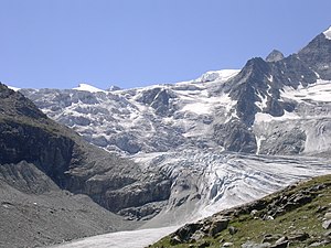
Moiry glacier
| Moiry glacier | ||
|---|---|---|
|
Moiry glacier from the north |
||
| location | Canton of Valais , Switzerland | |
| Mountains | Valais Alps | |
| Type | Valley glacier | |
| length | 5.2 km (2011) | |
| surface | 6.1 km² (1995) | |
| Exposure | North | |
| Altitude range | 3845 m above sea level M. - 2410 m above sea level M. (2005) | |
| Tilt | ⌀ 18.8 ° (34%) | |
| Ice volume | 0.33 ± 0.08 km³ (1993) | |
| Coordinates | 612 333 / 102 683 | |
|
|
||
| drainage | Gougra , Navisence , Rhone | |
The Moiry Glacier (French Glacier de Moiry ) is a glacier in the Valais Alps at the end of the Val de Moiry, a side valley of the Val d'Anniviers . It is about five kilometers south of the Lac de Moiry . The glacier is 5.2 km long and covers an area of approximately 6.1 km², the exposure is north.
Its starting point takes the moiry glacier on the northern flank of the Grand Cornier to around 3800 m From here it flows to the north, flanked by the Pointe de Bricola ( 3658 m above sea level. M. ) and the Tsa de l'Ano ( 3368 m above sea level. M. ) in the west and from the Bouquetins (up to 3627 m above sea level ) and the Pigne de la Lé ( 3396 m above sea level ) in the east. At the western foot of the Pigne de la Lé, the glacier overcomes a steep rocky edge, otherwise it has a relatively even slope of 15 to 20%. The glacier tongue currently ends at an altitude of around 2400 m . The Moiry glacier feeds the Gougra , which is dammed in the Lac de Moiry and then flows into the Navisence . This flows through the Val d'Anniviers and reaches the Rhone at Sierre .
At the end of the 19th century, the Moiry glacier reached a little more than half a kilometer further down the valley. The Cabane de Moiry , from which the glacier can be clearly seen, stands on a rocky slope east of the glacier.
Web links
- Panorama from the Pigne de la Lé, in the left half of the picture the Moiry glacier
- Map section at map.geo.admin.ch
- Video: Impressions of a hike to Cab. De Moiry and Glacier de Moiry
Individual evidence
- ↑ a b c Research Institute for Hydraulic Engineering, Hydrology and Glaciology (VAW) of the ETH Zurich (Ed.): Moirygletscher. In: Swiss Glacier Measurement Network. ( ethz.ch , also as PDF , accessed on January 30, 2014).
- ↑ a b c Daniel Farinotti, Matthias Huss, Andreas Bauder, Martin Funk: An estimate of the glacier ice volume in the Swiss Alps. In: Global and Planetary Change. 68: 225-231, 2009 ( online ; PDF; 756 kB).
- ↑ a b WGMS: Fluctuations of Glaciers Database. World Glacier Monitoring Service, Zurich 2013 ( DOI: 10.5904 / wgms-fog-2013-11 ), accessed on December 11, 2013
- ↑ Andreas Linsbauer, Frank Paul, Wilfried Haeberli: Modeling glacier thickness distribution and bed topography over entire mountain ranges with GlabTop: Application of a fast and robust approach. In: Journal of Geophysical Research. , Volume 117, F03007, 2012, doi : 10.1029 / 2011JF002313 ( online )

